Dunedin
The province and region of Otago takes its name from the Ngāi Tahu village of Otakou at the mouth of the harbour,[21] which became a whaling station in the 1830s.
A Scottish settlement was established in 1848 by the Lay Association of the Free Church of Scotland and between 1855 and 1900 many thousands of Scots emigrated to the incorporated city.
Dunedin's population and wealth boomed during the 1860s' Otago gold rush, and for a brief period of time it became New Zealand's largest urban area.
[25] Archaeological evidence shows the first human (Māori) occupation of New Zealand occurred between 1250 and 1300 AD,[4] with the population concentrated along the southeast coast.
[26][27] The population contracted but expanded again with the evolution of the Classic Māori culture which saw the building of several pā, fortified settlements, notably Pukekura at (Taiaroa Head), about 1650.
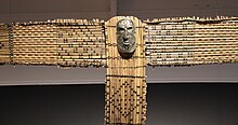
Māori tradition tells first of a people called Kahui Tipua living in the area, then Te Rapuwai, semi-legendary but considered[by whom?]
[32] Lieutenant James Cook stood off what is now the coast of Dunedin between 25 February 1770 and 5 March 1770, naming Cape Saunders (on the Otago Peninsula) and Saddle Hill.
Early in 1844, the Deborah, captained by Thomas Wing and carrying (among others) his wife Lucy and a representative of the New Zealand Company, Frederick Tuckett, sailed south from Nelson to determine the location of a planned Free Church settlement.
In 1861, the discovery of gold at Gabriel's Gully, to the south-west, led to a rapid influx of people and saw Dunedin become New Zealand's first city by growth of population in 1865.
After ten years of gold rushes the economy slowed but Julius Vogel's immigration and development scheme brought thousands more, especially to Dunedin and Otago, before recession set in again in the 1880s.
At the same time, people started to notice Dunedin's mellowing, the ageing of its grand old buildings, with writers like E. H. McCormick pointing out its atmospheric charm.
In the 1930s and early 1940s a new generation of artists such as M. T. (Toss) Woollaston, Doris Lusk, Anne Hamblett, Colin McCahon and Patrick Hayman once again represented the best of the country's talent.
The Second World War saw the dispersal of these painters, but not before McCahon had met a very youthful poet, James K. Baxter, in a central city studio.
Hallensteins was the colloquial name of a menswear manufacturer and national retail chain, while the DIC and Arthur Barnett were department stores, the former a nationwide concern.
This was a culturally vibrant time with the university's new privately endowed arts fellowships bringing writers including James K Baxter, Ralph Hotere, Janet Frame and Hone Tuwhare to the city.
[citation needed] During the 1980s Dunedin's popular music scene blossomed, with many acts, such as The Chills, The Clean, The Verlaines and Straitjacket Fits, gaining national and international recognition.
By 1990, population decline had steadied and slow growth has occurred since and Dunedin re-invented itself as a 'heritage city' with its main streets refurbished in the Victorian style.
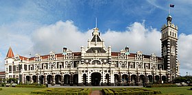
Many, including First Church, Otago Boys' High School and Larnach Castle were designed by one of New Zealand's most eminent architects R. A. Lawson.
[57][58][59] By early March 2021, the Southern District Health Board confirmed that test results indicated that long-term exposure to lead in the water supply posed little risk to the local population.
[61] The Dunedin City territorial authority has a land area of 3,314.8 km2 (1,279.9 sq mi), slightly larger than the American state of Rhode Island or the English county of Cambridgeshire, and a little smaller than Cornwall.
The Dunedin City Council boundaries since 1989 have extended to Middlemarch in the west, Waikouaiti in the north, the Pacific Ocean in the east and south-east, and the Waipori/Taieri River and the township of Henley in the south-west.
Close to the plain, much of this is forested, notably around Berwick and Lake Mahinerangi, and also around the Silverpeaks Range which lies northwest of the Dunedin urban area.
A high, broad valley, the Strath-Taieri lies in Dunedin's far northwest, containing the town of Middlemarch, one of the area's few concentrations of population.
To the north of the city's urban area is undulating hill country containing several small, mainly coastal, settlements, including Waitati, Warrington, Seacliff, and Waikouaiti.
The peninsula contains several fine beaches, and is home to a considerable number of rare species including Yellow-eyed and Little penguins, seals, and shags.
Taiaroa Head on the peninsula's northeastern point is a site of global ecological significance, as it is home to the world's only mainland breeding colony of royal albatross.
(clockwise from the city centre, starting at due north) Woodhaugh; Glenleith; Leith Valley; Dalmore; Liberton; Pine Hill; Normanby; Mt Mera; North East Valley; Opoho; Dunedin North; Ravensbourne; Highcliff; Shiel Hill; Challis; Waverley; Vauxhall; Ocean Grove (Tomahawk); Tainui; Andersons Bay; Musselburgh; South Dunedin; St Kilda; St Clair; Corstorphine; Kew; Forbury; Caversham; Concord; Maryhill; Kenmure; Mornington; Kaikorai Valley; City Rise; Belleknowes; Roslyn; Kaikorai; Wakari; Maori Hill.
[85] Among the bands with Dunedin connections were The Chills, The Clean, The Verlaines, The Bats, Sneaky Feelings, The Dead C and Straitjacket Fits, all of which had significant followings throughout New Zealand and on the college radio circuit in the United States and Europe.
Weekly and bi-weekly community newspapers include The Star, Taieri Herald, the fortnightly street press POINT, and the university student magazine Critic Te Ārohi.
The station is also sometimes visited by excursions organised by other heritage railway societies, and by trains chartered by cruise ships docking at Port Chalmers.