Earth observation satellite
[2] The United States Army Ballistic Missile Agency launched the first American satellite, Explorer 1, for NASA's Jet Propulsion Laboratory on January 31, 1958.
[1] By 2021, that total had grown to over 950, with the largest number of satellites operated by US-based company Planet Labs.
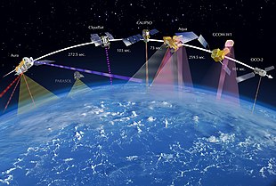
The Earth observation satellites ERS-1, ERS-2 and Envisat of European Space Agency as well as the MetOp spacecraft of EUMETSAT are all operated at altitudes of about 800 km (500 mi).
The Proba-1, Proba-2 and SMOS spacecraft of European Space Agency are observing the Earth from an altitude of about 700 km (430 mi).
Herman Potočnik explored the idea of using orbiting spacecraft for detailed peaceful and military observation of the ground in his 1928 book, The Problem of Space Travel.
[7] The onset of the Cold War prompted the rapid development of Satellite launch systems and camera technology capable of sufficient Earth observation to garner intelligence on enemy military infrastructure and evaluate nuclear posture.
[8] Following the U-2 incident in 1960, which highlighted the risks of aerial spying, the U.S. accelerated surveillance satellite programs like CORONA.
City lights, fires, effects of pollution, auroras, sand and dust storms, snow cover, ice mapping, boundaries of ocean currents, energy flows, etc., are other types of environmental information collected using weather satellites.
[12] For example, the 2002 oil spill off the northwest coast of Spain was watched carefully by the European ENVISAT, which, though not a weather satellite, flies an instrument (ASAR) which can see changes in the sea surface.