Effects of Hurricane Georges in Florida
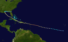
After weakening slightly to a Category 3, the cyclone proceeded to strike Antigua, Saint Kitts and Nevis, Puerto Rico, Dominican Republic, and Cuba.
With a landfall predicted along the mainland of Florida, the National Hurricane Center (NHC) issued tropical cyclone warnings and watches, while more than 1.2 million people were ordered to evacuate.
While approaching landfall in Mississippi, Georges generated storm surge and abnormally high tides along the coast of the Florida Panhandle, causing erosion and coastal flooding near the west end of the state.
After crossing into the panhandle, Georges dropped heavy rainfall, peaking at 38.46 in (977 mm) in Munson, flooding hundreds of homes in the region.
Tracking westward, the wave spawned an area of low pressure two days later, which quickly strengthened into a tropical depression.
The storm reached its peak intensity on September 20 with winds of 155 mph (249 km/h), just below Category 5 status on the Saffir–Simpson scale.
[1] Over the following five days, the hurricane tracked through the Greater Antilles, causing over 600 fatalities, mainly in the Dominican Republic and Haiti.
Despite the mandatory evacuation order, 20,000 people, including over 7,000 Key West citizens, refused to leave.
Long-time Florida Keys citizens noted the solitude of the time and enjoyed the island for how it once was, rather than the large crowds of tourists.
[2] Upon making landfall, Hurricane Georges brought a storm surge of up to 12 ft (3.7 m) in Tavernier, with similar but lesser amounts along the Florida Keys.
[6] A long-tracked F0 tornado, originally forming as a waterspout, moved from Key Biscayne to Cutler Ridge.
[12] In Charlotte County another F0 tornado tracked for 5 mi (8.0 km), uprooting several trees along its path before dissipating.
The first twister damaged awnings, blew over a few sheds, and downed large trees limbs and power lines just south of Winter Haven.
The other tornado, spawned about 7 mi (11 km) northwest of Lakeland damaged two barns and knocked a trailer off its foundation.
[12] Upon making landfall, Hurricane Georges produced a storm surge of up to 10 feet (3.0 m), with higher waves on top of it.
[16] High water near a levee threatened to break through and inundate a small town, resulting in the evacuation of 100 residents.
[20] Numerous creeks and rivers rose near or above flood stage throughout northern Florida due to the torrential rainfall from Georges.