Meteorological history of Hurricane Georges
Tracking westward, the wave spawned an area of low pressure two days later, which quickly strengthened into a tropical depression.
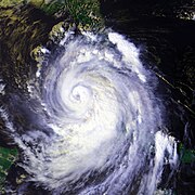
The storm reached its peak intensity on September 20 with winds of 155 mph (250 km/h), just below Category 5 status on the Saffir–Simpson hurricane scale, and a barometric pressure of 937 mbar (hPa; 27.67 inHg).
Several hours prior to landfall the next day, the hurricane weakened slightly and tracked inland near Biloxi, Mississippi with winds of 105 mph (170 km/h).
By September 15, ships within the vicinity of the wave reported that a surface circulation had developed and by 1200 UTC, the National Hurricane Center (NHC) estimated that a tropical depression, the seventh of the season, while situated about 345 miles (555 kilometres) south-southwest of the Cape Verde Islands.
[1] The depression tracked roughly due west in response to a mid-level ridge, building westward, to the north of the cyclone.
[6] Later on September 17, a banding-eye feature appeared on satellite imagery, leading the NHC to upgrade Georges into a hurricane at 1800 UTC that day.
[1] Ahead of the storm, the NHC reported that there were no factors inhibiting further intensification and anticipated Georges to strengthen into a Category 4 hurricane before reaching the Lesser Antilles.
At the end of this phase, Georges attained its peak intensity with winds of 155 mph (250 km/h) and a barometric pressure of 937 mbar (hPa; 27.67 inHg), just below Category 5 status.
[12] Shortly after attaining peak intensity on September 20, Georges began to weaken, as upper-level vertical wind shear caused the eye to become cloud-filled and was no longer visible on satellite imagery.
[15] As the storm approached Puerto Rico late on September 21, the wind shear began to relent, allowing Georges to re-organize;[16] however, its outflow was unable to fully redevelop due to its proximity to land.
[1] Later on September 23, the storm entered the Windward Passage,[1] maintaining a broad circulation with well-defined banding and an eye-like feature.
[20] Little change occurred during the day; the storm made its fifth landfall near Guantanamo Bay, Cuba with winds of 75 mph (120 km/h).
[23] The reorganization led to an increase in intensity, and at about 1530 UTC, Georges made landfall near Key West with winds of 105 mph (170 km/h).
[1] The hurricane's forward motion shifted to west-northwest, and forecast models indicated that Georges would re-attain Category 3 status before making landfall along the northern Gulf Coast.
Vertical wind shear was estimated at up to 35 mph (55 km/h), restricting outflow within the hurricane and confining the most intense convection to the eastern side of the circulation.
[30] The storm's slow movement led to extreme amounts of rainfall throughout the southeastern United States,[1] peaking at 38.46 in (977 mm) in Munson, Florida.
[36] The HPC issued their final advisory on the depression early on October 1 as it neared the Atlantic Ocean,[37] and it fully dissipated several hours later.