Error analysis for the Global Positioning System
However, the advancement of technology means that in the present, civilian GPS fixes under a clear view of the sky are on average accurate to about 5 meters (16 ft) horizontally.
A detailed description of how to calculate PDOP is given in the section Geometric dilution of precision computation (GDOP).
[1] Some military and expensive survey-grade civilian receivers calculate atmospheric dispersion from the different delays in the L1 and L2 frequencies, and apply a more precise correction.
This can be done in civilian receivers without decrypting the P(Y) signal carried on L2, by tracking the carrier wave instead of the modulated code.
To facilitate this on lower cost receivers, a new civilian code signal on L2, called L2C, was added to the Block IIR-M satellites, which was first launched in 2005.
Several systems send this information over radio or other links to allow L1-only receivers to make ionospheric corrections.
These traits make precise measurement and compensation of humidity errors more difficult than ionospheric effects.
[2] The Atmospheric pressure can also change the signals reception delay, due to the dry gases present at the troposphere (78% N2, 21% O2, 0.9% Ar...).
Its effect varies with local temperature and atmospheric pressure in quite a predictable manner using the laws of the ideal gases.
[4] A variety of techniques, most notably narrow correlator spacing, have been developed to mitigate multipath errors.
[7] For very precise positioning (e.g., in geodesy), these effects can be eliminated by differential GPS: the simultaneous use of two or more receivers at several survey points.
DGPS also corrects for several other important sources of GPS errors, particularly ionospheric delay, so it continues to be widely used even though SA has been turned off.
The amount of error added was "set to zero"[10] at midnight on May 1, 2000 following an announcement by U.S. President Bill Clinton, allowing users access to the error-free L1 signal.
Clinton's executive order required SA to be set to zero by 2006; it happened in 2000 once the U.S. military developed a new system that provides the ability to deny GPS (and other navigation services) to hostile forces in a specific area of crisis without affecting the rest of the world or its own military systems.
[10] On 19 September 2007, the United States Department of Defense announced that future GPS III satellites will not be capable of implementing SA,[11] eventually making the policy permanent.
Turning off antispoof would primarily benefit surveyors and some scientists who need extremely precise positions for experiments such as tracking tectonic plate motion.
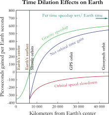
The theory of relativity introduces several effects that need to be taken into account when dealing with precise time measurements.
The special relativistic effect is due to the constant movement of GPS clocks relative to the Earth-centered, non-rotating approximately inertial reference frame.
Special relativity allows the comparison of clocks only in a flat spacetime, which neglects gravitational effects on the passage of time.
[15] Since the atomic clocks on board the GPS satellites are precisely tuned, it makes the system a practical engineering application of the scientific theory of relativity in a real-world environment.
[16] Placing atomic clocks on artificial satellites to test Einstein's general theory was proposed by Friedwardt Winterberg in 1955.
changes by (the inverse of) the Lorentz factor: For small values of v/c this approximates to: The GPS satellites move at 3874 m/s relative to Earth's center.
The resulting signal run time correction has opposite algebraic signs for satellites in the Eastern and Western celestial hemispheres.
Ignoring this effect will produce an east–west error on the order of hundreds of nanoseconds, or tens of meters in position.
In one well-documented case it was impossible to receive GPS signals in the entire harbor of Moss Landing, California due to unintentional jamming caused by malfunctioning TV antenna preamplifiers.
Generally, stronger signals can interfere with GPS receivers when they are within radio range or line of sight.
In 2002 a detailed description of how to build a short-range GPS L1 C/A jammer was published in the online magazine Phrack.
[30] A GPS jammer is relatively easy to detect and locate, making it an attractive target for anti-radiation missiles.
Due to the potential for both natural and man-made noise, numerous techniques continue to be developed to deal with the interference.
The U.S. military has also deployed since 2004 their Selective Availability / Anti-Spoofing Module (SAASM) in the Defense Advanced GPS Receiver (DAGR).