El Yunque National Forest
Other peaks within the national forest are Pico del Este, Pico del Oeste, El Cacique and the highest peak, El Toro, which is the highest point in the national forest and in eastern Puerto Rico rising 3,494 feet (1,065 m) above sea level.
It is said that indigenous people believed that El Yunque was the throne of their chief god Yúcahu, so that it is the Caribbean equivalent to Mount Olympus in Greek mythology.
The forest today is home to several archaeological sites related to the indigenous Taínos, such as the Río Blanco petroglyphs, although no evidence of permanent settlement has been found in the area, which suggests that it was possibly avoided and most likely considered sacred.
The area where El Portal Rainforest Visitor Center is located used to be the site of a coffee plantation named Hacienda Catalina.
Coffee was introduced and cultivated in the slopes of El Yunque in the 1730s but the area remained relatively untouched until the 19th century when the lowland forests were exploited for timber and cut down for the development of agriculture, which attracted the attention of the Spanish Crown.
Due to the rapid population growth in the island and the poor farming practices of the impoverished European immigrants of the time, the forest region was formally set aside in 1876 by King Alfonso XII of Spain with the purpose of preserving the soil and water resources and regulating the timber industry in the region.
This makes El Yunque one of the oldest reserves in the Western Hemisphere, only four years younger than Yellowstone National Park.
[7] The National Science Foundation established El Verde Field Station in 1988 under an agreement with the US Forest Service as a primary site for the Luquillo Long-Term ecological Research (Luquillo-LTER, now managed by the University of Puerto Rico, Rio Piedras) with the goal of supporting scientific research of tropical ecosystems due to the occurrence of five out of six of Holdridge's life zones and forest types.
[12] Hurricanes Irma and Maria caused deforestation, landslides and heavy damage to the forest and its infrastructure in 2017, drastically reducing the Puerto Rican parrot population once again.
El Yunque National Forest today extends over 28,000 acres through the municipalities of Río Grande, Luquillo, Naguabo, Ceiba, Fajardo, Canóvanas, Las Piedras and Juncos.
[13] Due to its location in the northeastern part of Puerto Rico, the incoming trade winds from the Atlantic Ocean bash into the mountains, leading to an excess of rainfall registered at about 240 inches (6.1 m) per year.
[13] This process is called orographic lift and accounts for the intense rainfall and constant cloud presence in this mountainous region.
This constant cloud cover and persistent winds produced by the adiabatic process of air particles rushing up through the mountainside has affected the morphology of El Yunque, but the most effect has been on the bosque enano or dwarf forest.
Due to the shallowness of its bark, the trunks of these trees are commonly used as nesting sites by endangered Puerto Rican parrots (Amazona vittata).
The tabonuco tree (Dacryodes excelsa) from which this forest area got its name occurs from 660 to 2800 feet (200 to 900 meters) in the mountains of Puerto Rico as well as other islands that make up the Antilles.
This forest is very diverse in trees, having over 170 species such as bulletwood (Manilkara bidentata), West Indian giant fern (Cyathea arborea), yarumo (Cecropia peltata), macho yarumo (Didymopanax morototoni), granadillo (Buchenavia capitata) and guaraguao tree (Guarea guidona).
The vegetation shows stunted growth in which the diameter of the trunk is widened and the number of leaves on the branches is lower than expected.
[14] Other specific factors that affect the growth of this sub-region are the high level of acidity and poor water runoff from the soil.
The endangered American eel (Anguilla rostrata), the fat sleeper fish (Dormitator maculatus), the bigmouth sleeper fish (Gobiomorus dormitor), big claw river shrimp (Macrobrachium carcinus) and the bocú shrimp (Macrobrachium crenulatum) are found in the rivers and creeks that originate and flow from El Yunque.
[23] Approximately 16 species of common coqui, members of the diverse neotropical frog genus Eleutherodactylus, are known in Puerto Rico.
Per a study published October 2018, by Bradford C. Lister and Andres Garcia, arthropod biomass in the Luquillo rainforest data taken during the 1970s compared to 30 years later has fallen 10 to 60 times.
The summit is part of the cloud forest and it hosts a small lookout tower built by the Civilian Conservation Corps in 1937 that on clear days offers views of both the Atlantic Ocean and the Caribbean Sea.
The trail crosses numerous small steams, waterfalls and a tabonuco tree forest and leads to the lush Mameyes Wild & Scenic River area.
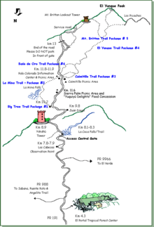
[48] La Mina Trail is a moderate to difficult 0.7-mile-long mile that starts on PR-191 close to the Palo Colorado Information Center.
This is another popular hiking trail as it leads to La Mina Falls, one of the most picturesque waterfalls of the national forest.
The trail was originally built by the Civilian Conservation Corps in the 1930s and remained close for many decades but it was finally reopened in 2011 as part of the Sabana Recreation Area.
[53][54] El Yunque National Forest offers many opportunities for swimming in natural pools often found at the base of waterfalls, such as that of La Mina Falls and the Juan Diego area off PR-191.
[56] These manmade pools were built by the Civilian Conservation Corps during the New Deal era by damming creeks belonging to the La Mina River watershed.
[61] The entry experience begins atop an elevated walkway that unites the facility with the surrounding forest and provides views to the mountain peaks, ocean and reforested terrain.
[68] Contrary to the popular assumption, El Yunque Peak is not the highest mountain in either the Sierra de Luquillo or Puerto Rico.