Erosion
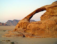
Agents of erosion include rainfall;[4] bedrock wear in rivers; coastal erosion by the sea and waves; glacial plucking, abrasion, and scour; areal flooding; wind abrasion; groundwater processes; and mass movement processes in steep landscapes like landslides and debris flows.
Typically, physical erosion proceeds the fastest on steeply sloping surfaces, and rates may also be sensitive to some climatically controlled properties including amounts of water supplied (e.g., by rain), storminess, wind speed, wave fetch, or atmospheric temperature (especially for some ice-related processes).
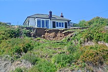
On-site impacts include decreases in agricultural productivity and (on natural landscapes) ecological collapse, both because of loss of the nutrient-rich upper soil layers.
Off-site effects include sedimentation of waterways and eutrophication of water bodies, as well as sediment-related damage to roads and houses.
[9]: 2 [10]: 1 [11] Intensive agriculture, deforestation, roads, anthropogenic climate change and urban sprawl are amongst the most significant human activities in regard to their effect on stimulating erosion.
This means that rills exhibit hydraulic physics very different from water flowing through the deeper, wider channels of streams and rivers.
Gully erosion occurs when runoff water accumulates and rapidly flows in narrow channels during or immediately after heavy rains or melting snow, removing soil to a considerable depth.
[17][18][19] A gully is distinguished from a rill based on a critical cross-sectional area of at least one square foot, i.e. the size of a channel that can no longer be erased via normal tillage operations.
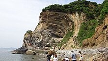
Thermal erosion also affects the Arctic coast, where wave action and near-shore temperatures combine to undercut permafrost bluffs along the shoreline and cause them to fail.
These banks may slowly migrate along the coast in the direction of the longshore drift, alternately protecting and exposing parts of the coastline.
In an abrasion process, debris in the basal ice scrapes along the bed, polishing and gouging the underlying rocks, similar to sandpaper on wood.
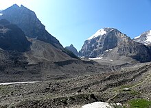
Scientists have shown that, in addition to the role of temperature played in valley-deepening, other glaciological processes, such as erosion also control cross-valley variations.
Differences in the height of mountain ranges are not only being the result tectonic forces, such as rock uplift, but also local climate variations.
Scientists have proved this theory by sampling eight summits of northwestern Svalbard using Be10 and Al26, showing that northwestern Svalbard transformed from a glacier-erosion state under relatively mild glacial maxima temperature, to a glacier-armor state occupied by cold-based, protective ice during much colder glacial maxima temperatures as the Quaternary ice age progressed.
[41] The best-developed glacial valley morphology appears to be restricted to landscapes with low rock uplift rates (less than or equal to 2mm per year) and high relief, leading to long-turnover times.
Where rock uplift rates exceed 2mm per year, glacial valley morphology has generally been significantly modified in postglacial time.
Kolks cause extreme local erosion, plucking bedrock and creating pothole-type geographical features called rock-cut basins.
It is also a major source of land degradation, evaporation, desertification, harmful airborne dust, and crop damage—especially after being increased far above natural rates by human activities such as deforestation, urbanization, and agriculture.
[49][50] Mass wasting is an important part of the erosional process and is often the first stage in the breakdown and transport of weathered materials in mountainous areas.
[citation needed] Slumping happens on steep hillsides, occurring along distinct fracture zones, often within materials like clay that, once released, may move quite rapidly downhill.
Turbidity currents can erode channels and canyons into substrates ranging from recently deposited unconsolidated sediments to hard crystalline bedrock.
In general, given similar vegetation and ecosystems, areas with more precipitation (especially high-intensity rainfall), more wind, or more storms are expected to have more erosion.
[61] In other regions of the world (e.g. western Europe), runoff and erosion result from relatively low intensities of stratiform rainfall falling onto the previously saturated soil.
The removal by erosion of large amounts of rock from a particular region, and its deposition elsewhere, can result in a lightening of the load on the lower crust and mantle.
[51]: 99 [68] In some cases, it has been hypothesised that these twin feedbacks can act to localize and enhance zones of very rapid exhumation of deep crustal rocks beneath places on the Earth's surface with extremely high erosion rates, for example, beneath the extremely steep terrain of Nanga Parbat in the western Himalayas.
Scholars Pitman and Golovchenko estimate that it takes probably more than 450 million years to erode a mountain mass similar to the Himalaya into an almost-flat peneplain if there are no significant sea-level changes.
Erosion of this orogen has produced sediments that are now found in the East European Platform, including the Cambrian Sablya Formation near Lake Ladoga.
On-site impacts include decreases in agricultural productivity and (on natural landscapes) ecological collapse, both because of loss of the nutrient-rich upper soil layers.
Off-site effects include sedimentation of waterways and eutrophication of water bodies, as well as sediment-related damage to roads and houses.
[10][78] Often in the United States, farmers cultivating highly erodible land must comply with a conservation plan to be eligible for agricultural assistance.