European Climate Assessment and Dataset
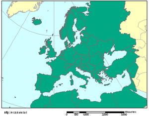
The European Climate Assessment and Dataset (ECA&D) is a database of daily meteorological station observations across Europe and is gradually being extended to countries in the Middle East and North Africa.
Included in the database is a collection of daily series observations obtained from climatological divisions of National Meteorological and Hydrological Services (NMHSs), observatories and research centres throughout Europe and the Mediterranean.
The daily series of observations is combined with quality control and analysis of extremes via climate change indices.
[1] The ECA&D project is initiated by the European Climate Support Network (ECSN) and is coordinated at the Royal Netherlands Meteorological Institute (Dutch: Koninklijk Nederlands Meteorologisch Instituut or KNMI) which now funds the project after it was initially funded by EUMETNET, the network of European national meteorological services.
As of June 2010[update], the European Climate Assessment and Dataset contains 13472 series of observations at 3314 meteorological stations provided by 56 participants from 61 different countries and is constantly expanding.
These participants contribute daily, quality controlled data from (a subset) of their national meteorological station networks.
In order to ensure that each station's time series are as complete as possible, the database contains an automated update procedure that relies on daily data from SYNOP (surface synoptic observations) messages that are distributed in near real-time over the Global Telecommunication System (GTS).
Any gaps in data are infilled with observations from nearby stations, provided they are within a 25 kilometres (16 mi) distance radius and within a height range of less than 50 metres (160 ft).
In contrast, the number of stations currently providing data for the other elements ranges from approximately 150 (wind direction) to 900 (snow depth).
Other examples of metadata are the land use around the observing area, soil type, surface coverage, station relocations and/or instrument changes.
Any gaps in data are infilled with observations from nearby stations, provided they are within a 25 kilometres (16 mi) distance radius and within a height range of less than 50 metres (160 ft).
However, single events cannot simply and directly be attributed to anthropogenic climate change as there is always a finite chance that the event in question may have occurred within natural variability; but, according to the latest report from the Intergovernmental Panel on Climate Change (IPCC), "Confidence has increased that some extremes will become more frequent, widespread and/or more intense during the 21st century.
The E–OBS daily gridded dataset covering Europe, the Middle East and Northern Africa has been developed as part of the ENSEMBLES project and is available from 1950 onwards.