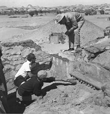
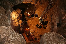
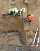
Archaeological excavation
This data includes artifacts (portable objects made or modified by humans), features (non-portable modifications to the site itself such as post molds, burials, and hearths), ecofacts (evidence of human activity through organic remains such as animal bones, pollen, or charcoal), and archaeological context (relationships among the other types of data).
[2][3][4][5] Before excavating, the presence or absence of archaeological remains can often be suggested by, non-intrusive remote sensing, such as ground-penetrating radar.
[8] Antiquarians excavated burial mounds in North America and North-West Europe, which sometimes involved destroying artifacts and their context, losing information about subjects from the past.
Meticulous and methodical archaeological excavation took over from antiquarian barrow-digging around the early to mid-nineteenth century and is still being perfected today.
[9][8] The most dramatic change that occurred over time is the amount of recording and care taken to ensure preservation of artifacts and features.
Modern archaeological excavation has evolved to include removal of thin layers of sediment sequentially and recording of measurements about artifacts' locations in a site.
In the US, a method of evaluation called a Shovel test pit is used which is a specified half meter square line of trial trenches dug by hand.
A gardener swept a pile of soil into a corner, laid a gravel path or planted a bush in a hole.
The prominent processual archaeologist Lewis Binford highlighted the fact that the archaeological evidence left at a site may not be entirely indicative of the historical events that actually took place there.
Using an ethnoarchaeological comparison, he looked at how hunters amongst the Nunamiut Iñupiat of north central Alaska spent a great deal of time in a certain area simply waiting for prey to arrive there, and that during this period, they undertook other tasks to pass the time, such as the carving of various objects, including a wooden mould for a mask, a horn spoon and an ivory needle, as well as repairing a skin pouch and a pair of caribou skin socks.
As he remarked, waiting for animals to hunt "represented 24% of the total man-hours of activity recorded; yet there is no recognisable archaeological consequences of this behaviour.
It is more useful to think of this higher or lower term as it relates to the contexts position in a Harris matrix, which is a two-dimensional representation of a site's formation in space and time.
The terminology of these larger clusters varies depending on practitioner, but the terms interface, sub-group, group and land use are common.
Phase is the most easily understood grouping for the layman as it implies a near contemporaneous Archaeological horizon representing "what you would see if you went back to a specific point in time".
Phasing a site represents reducing the site either in excavation or post-excavation to contemporaneous horizons whereas "digging in phase" is the process of stratigraphic removal of archaeological remains so as not to remove contexts that are earlier in time "lower in the sequence" before other contexts that have a latter physical stratigraphic relationship to them as defined by the law of superposition.
In stratigraphic excavation, the goal is to remove some or, preferably, all archaeological deposits and features in the reverse order they were created and construct a Harris matrix as a chronological record or "sequence" of the site.
"Strip, map and sample" is a method of excavation applied in the United Kingdom to preserve archaeological remains by record in the face of development threats.
[citation needed] This describes the use in excavations of various types and sizes of machines from small backhoes to heavy duty earth-moving machinery.
Machines are often used in what is called salvage or rescue archaeology in developer-led excavation when there are financial or time pressures.
Rosemary Hill describes how Geoffrey Wainwright "oversaw large, high-speed excavations, taking bulldozers to the site in a manner that shocked some of his colleagues but yielded valuable if tantalising information about what Durrington had looked like and how it might have been used.
Heights are recorded with a dumpy level or total station by relation to the site temporary benchmark (abbr.
Spoil is shoveled into cement mixers and water added to form a slurry which is then poured through a large screen mesh.
Spot dating also forms part of a confirmation process, of assessing the validity of the working hypothesis on the phasing of site during excavation.
For example, the presence of an anomalous medieval pottery sherd in what was thought to be an Iron Age ditch feature could radically alter onsite thinking on the correct strategy for digging a site and save a lot of information being lost due to incorrect assumptions about the nature of the deposits which will be destroyed by the excavation process and in turn, limit the site's potential for revealing information for post-excavation specialists.