Executive Committee Range
Named features of Mount Sidley include Feyerharm Knoll, Weiss Amphitheater, Parks Glacier and Doumani Peak.
[2][3] In November 2013, Lough et al. reported deep long period volcanic earthquakes centered at depths of 30-40 km approximately 55 km S of Mount Sidley that were interpreted as indications of present deep crustal magmatic activity beneath the Executive Committee Range.
Ice penetrating radar results reported in this study indicated a sub-ice topographic feature, interpreted as a volcano, above the seismic swarms.
The study also reported a mid-icecap (1400 m depth) ash layer about 8,000 years old that was interpreted as probably originating at nearby Mount Waesche.
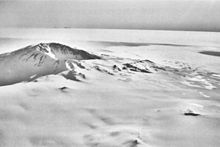
Mount Sidley, the most imposing mountain in the range, was discovered and named by Rear Admiral Richard E. Byrd in 1934.
An impressive mountain 3,325 metres (10,909 ft) high with a circular ice-filled crater occupying much of the summit area.
A conspicuous peak 3,005 metres (9,859 ft) high rising 3 nautical miles (5.6 km; 3.5 mi) northwest of Mount Hampton, from which it is separated by a distinctive ice-covered saddle.
Named by the United States Advisory Committee on Antarctic Names (US-ACAN) for Captain Herbert Whitney, United States Navy Reserve, commander of the Navy's Mobile Construction Battalion responsible for the building of Antarctic stations for use during the International Geophysical Year.
A rocky peak 3,325 metres (10,909 ft) high on the south side of the crater rim of Mount Hampton.
Named by US-ACAN for Keith E. Marks, electronics engineer, National Bureau of Standards, a member of the Marie Byrd Land Traverse Party, 1959-60.
A partially ice-free peak 2,610 metres (8,560 ft) high on the west side of the crater rim of Mount Cumming.
It is situated immediately north of Mount Sidley in the Executive Committee Range, Marie Byrd Land.
A snow-capped peak which rises to 2,745 metres (9,006 ft) high in the northeast portion of Mount Hartigan.
Named by US-ACAN for Eugene L. Boudette, Geologist, USGS, a member of the Marie Byrd Land Traverse Party, 1959-60.
Mapped by USGS from surveys and United States Navy trimetrogon photography, 1958-60, Named by US-ACAN for Alien D. Tusing, meteorologist at Byrd Station, 1959.
An amphitheater-like caldera, 2 nautical miles (3.7 km; 2.3 mi) wide and breached at the southern side, occupying the south-central part of Mount Sidley.
Named by US-ACAN for Perry E. Parks, Jr., exploration geophysicist and assistant seismologist on the Marie Byrd Land Traverse, 1959-60.
A large and prominent mountain 3,290 metres (10,790 ft) high of volcanic origin, standing immediately southwest of Mount Sidley and marking the southern end of the Executive Committee Range.
Named for V. Admiral Russell R. Waesche, United States Coast Guard, member of the Antarctic Service Executive Committee.