Fife
The hill-fort of Clatchard Craig, near Newburgh, was occupied as an important Pictish stronghold between the sixth and eighth centuries AD.
[4][5] Fife was an important royal and political centre from the reign of King Malcolm III onwards, as the leaders of Scotland gradually moved southwards away from their ancient strongholds around Scone.
The Abbey replaced Iona as the final resting place of Scotland's royal elite, with Robert I amongst those to be buried there.
[6] The Earl of Fife was until the 15th century considered the principal peer of the Scottish realm, and reserved the right of crowning the nation's monarchs, reflecting the prestige of the area.
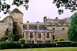
A new royal palace was gradually constructed at Falkland, formerly the stronghold of Clan MacDuff, and was used by successive monarchs of the House of Stuart, who favoured Fife for its rich hunting grounds.
The distinctive red clay pan tiles seen on many old buildings in Fife arrived as ballast on trading boats and replaced the previously thatched roofs.
Previously rural villages such as Cowdenbeath rapidly swelled into towns as thousands moved to Fife to find work in its mines.
The opening of the Forth and Tay rail bridges linked Fife with Dundee and Edinburgh and allowed the rapid transport of goods.
Originally to provide housing for miners at a new coal mine, the town eventually attracted a high number of modern Silicon Glen companies to the region.
The early province of Fife appears to have covered only that part of the later county lying east of a line from Newburgh to Scoonie.
In 1667 Commissioners of Supply were established for each shire, which would serve as the main administrative body for the area until the creation of county councils in 1890.
[15] Elected county councils were established in 1890 under the Local Government (Scotland) Act 1889, taking most of the functions of the commissioners (which were eventually abolished in 1930).
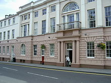
The two burghs of Dunfermline and Kirkcaldy were deemed capable of managing their own affairs and so were excluded from the administrative area of the county council.
[17] Dunfermline and Kirkcaldy were brought within the administrative area of the county council in 1930, but classed as large burghs, allowing them to continue to deliver many local government functions themselves.
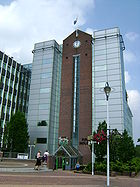
The west wing of the building was built by the Glenrothes Development Corporation (GDC) as their offices in 1969, which was later used as the headquarters of Fife Regional Council from shortly after its creation in 1975.
The coast has fine but small harbours, from the industrial docks in Burntisland and Rosyth to the fishing villages of the East Neuk such as Anstruther and Pittenweem.
The large area of flat land to the north of the Lomond Hills, through which the River Eden flows, is known as the Howe of Fife.
The areas in the south and west of Fife, including the towns of Dunfermline, Glenrothes, Kirkcaldy and the Levenmouth region are lightly industrial and more densely populated.
The only areas which could claim to be heavily industrial are Rosyth, around the naval dockyard and perhaps the Mossmorran Natural Gas Liquids fractionation plant on the outskirts of Cowdenbeath.
The east corner of Fife, along the string of villages between Earlsferry and Kingsbarns, and along with their hinterland, is known as the East Neuk (corner, or projecting point of land) of Fife;[28] small settlements around sheltered harbours, with distinctive vernacular "Dutch" or corbie (crow) stepped gabled and stone-built architecture.
Glenrothes is now the administrative centre, after the decision to locate the headquarters of the newly established Fife Regional Council there in 1975.
[42] St Andrews in Fife is the home of golf, and the headquarters of The R&A, the governing body of the sport throughout the world, aside from the United States and Mexico.
Kingdom Kangaroos are Fife's only Australian Rules Football team, with training held in Rosyth and Kirkcaldy.