Fils (river)
Through Geislingen an der Steige, the Filstal describes a 90 degree left turn, where the Eyb (river), which flows in from the northeast, joins in.
The Eyb river absorbs a northwestern tributary from Amstetten before its mouth, which is why Geislingen lies in a wide valley spider.
From now on, the Fils also runs in a northwesterly direction through its outlet bay from the Alb into the Swabian Keuper-Lias Plains, where Kuchen and then at the tributary of the Marrbach Gingen lie.
In the now wide valley follow Salach, Eislingen with the Krumm from the right, the second largest tributary of the Fils, and the left Weilerbach, then Göppingen, Faurndau with the Marbach.
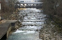
Thereupon the Fils reaches Plochingen, where it flows at 248.3 m after about 63 kilometres and almost 377 metres of altitude below its source from the right into the left curve of the Neckar there; it thus has a mean bottom gradient of about 6°.
At first, the river runs approximately east-northeast until its turning point from Geislingen through the Mittlere Kuppenalb and towards the end also has an inflow from the Albuch and Härtsfeld in the east.