Fort de Bertheaume
[citation needed] A plausible origin is that the fort was named for Saint Bertram, the founder of the city of Stafford.
[citation needed] Alternatively, the name has been etymologised as Breton [A]ber C'homm ('bay of the valley', related to the Welsh words aber and cwm.
Some shards of pottery date back to the 2nd and 3rd Centuries C.E., and there are fragments of tile, but the remnants are too few to suggest a durable Roman presence.
Saint Sané landed on the beach of the Perzel and then, with 50 followers, moved a few miles inland to establish the parish of Plouzané.
In the morning of 29 July 1558, an Anglo-Dutch force of 100 vessels landed 7000 men on the Blancs Sablons (White Sands; 48°22′10″N 4°45′52″W / 48.36944°N 4.76444°W / 48.36944; -4.76444).
[2] On 14 October 1585, François, son of Olivier Kerannou de Kervasdoué, captain of the castle of Bertheaume, was baptised.
In 1677, the French engineer Sainte Colombe proposed to Louis XIV of France "to install cannons on the small island of Bertheaume near the port of Trehire on the ruins of the castle of the former Dukes of Brittany".
Vauban, attempting to enhance the defense of Brest, established a battery in 1689 to repel potential English attack.
However, only in May 1699 did Vauban present plans to build a small fort with a battery on the island that would command the roads of Berteaume and its bay, where vessels waiting for favourable winds to enable them to sail into Brest harbour would anchor.
Construction of a more elaborate fort began in 1700 under Benoît de Musinot, an artillery officer with the Navy at Brest, and inventor of a swiveling mortar.
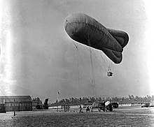
As Britain and France were allied during World War I, the fort lost its role in protecting Brest from the Royal Navy.
Observers in the balloons kept watch for German U-boats, especially as convoys started arriving at Brest in 1917 bringing U.S. troops.
The Germans occupied the site in 1940 and gradually enhanced the defenses, building a small, modern concrete blockhouse on the island.
After the war, the island and the land site came under the purview of the Ministry of Defence, which ignored them for 45 years, abandoning them to the growth of vegetation.
Since then the fort and the surrounding area have been subject to archaeological examination and undergone rehabilitation to make the site visitable.