Fort de Valros
The site has no visible trace of occupation from antiquity, but archaeological digs have uncovered the remains of a necropolis used from the 8th to the 10th century.
At 100 m altitude, it dominates the valley of the Thongue and controls two very ancient communication routes : the roads from Béziers to Pézenas and from Saint-Thibéry to Alignan-du-Vent.
From historical records, it is known that in 1199, the powerful Viscount of Béziers, Raymond Roger Trencavel, authorised his vassal Etienne de Servian to build a forcia on the podium of Valros.
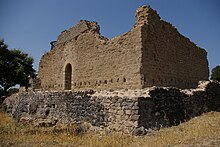
[1] The fort was protected externally by a dry moat and a first enceinte, the braie, defining a peripheral circuit, the lice.
The shortest distance from the bridge to the entrance to the fort obliged an assailant to go left along the wall, exposing his right side, the most vulnerable because not protected by armour.
To the left of the door, traces of projecting stones suggest the presence of a staircase giving access to the round walk.
[1] The small square tower nestled in the south west corner of the fortress (number 7 on the plan above) is a remnant of the aerial telegraphy invented at the end of the 18th century by the engineer Claude Chappe (1763-1805), using semaphore signals.
The mast extended down into the interior of the tower into a tight room, 3 m by 3 m, sheltering the stationnaire, the solitary worker glued to his telescopes.