Fortifications of Frankfurt
After its defeat in the Kronberg Feud in 1389, Frankfurt consistently avoided military conflicts and relied on its diplomatic relationships throughout the Holy Roman Empire and beyond.
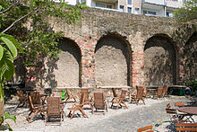
Various components of the fortifications are preserved, including: seven towers, among them the Eschenheimer Turm; a 200-metre stretch of the Staufenmauer; remnants of the landwehr border; and a 90-metre section of a casemate, discovered in 2009, which once formed part of the baroque bastion fortress.
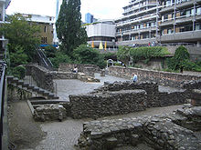
When parts of the wall were brought to light during the construction of the Dompfarrhaus on the northern Domplatz in 1827, and later in the cellars of houses in the western Altstadt area, Ulrich's description of the early medieval fortification was considered to be confirmed.
[4] During the construction of the Braubachstrasse through the Altstadt from 1904 to 1906 Christian Ludwig Thomas, an architect commissioned by the Historical Museum of Frankfurt, was able to confirm the northern and north-western position of the wall by sinking over 50 excavation shafts.
The fortification was made up of coarse gravel and rough-hewn quarried stone, but also contained higher-quality pieces of sandstone from Vilbel and basalt, possibly taken from demolished Roman structures.
Additionally, an official document from 994 describes the city as "castello" (a fortress),[11] making it reasonable to assume that the wall existed in 994, matching the archaeological findings.
The fortification ran between the Hainer Hof north of the Kannengiessergasse and a 1.1 metres (3 ft 7 in) wide gate discovered by Thomas in the area of the Borngasse.
The discovery of an east-west wall at the northern Samstagsberg presupposes the existence of another gate at the position where one leaves the Römerberg today, entering the Alter Markt in the direction of the cathedral.
By the end of the twelfth or the beginning of the thirteenth century, the enlarged settlement was surrounded by a new wall, the Staufenmauer, enclosing the area of about 0.5 square kilometres, known as the Frankfurter Altstadt.
[16] The new wall was located on the bank of the Main river, a little above the bridge,[b] running to the north along the Wollgraben up to the later Dominikanerkloster, and from there in a large arc north-west towards the Bornheimer Pforte at the Fahrgasse.
From there, it ran in a westerly direction along the Holzgraben towards the Katharinenpforte, then in an arc along the Kleiner and Grosser Hirschgraben towards the south-west, and made a sharp turn just before the western end of the Weissfrauenstrasse, towards the Main in the south.
There were three main gates: the Guldenpforte at the western end of the Weissadlergasse; the Bockenheimer Pforte between the Holzgraben and the Hirschgraben; and the Bornheimer Pforte'at the northernmost point of the Fahrgasse.
In early 1393 plans to mark the border of the city's territory with a ditch and a thick hedge – a traditional form of demarcation known as a landwehr (land defence) – were developed.
These measures attracted the attention and displeasure of Werner von Falkenstein, archbishop of the Trier, lord of Königstein and count of Castle Hayn [de].
King Sigismund, who was in London at time of the destruction, urged the archbishop to behave peacefully, and asked the city council to wait for his return to Germany to make a decision.
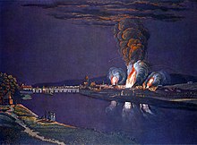
[37] During the Second Schmalkaldic War, Protestant troops under the command of Maurice, Elector of Saxony, broke through the landwehr and they set up camp directly in front of the city wall.
The city was successfully protected by troops of the Catholic emperor under the command of Conrad von Hanstein [de], due to a resolute defence by numerous cannon.
To achieve this victory, Hanstein ordered rapid improvements in the fortifications: the creation of makeshift bastions; and the demolition of the gothic spires on the Bockenheimer and Friedberger gate that had blocked the line of fire of the defence's artillery.
In 1618, the Thirty Years' War began causing the city council to consult the engineer Adam Stapf, who was working as a fortress architect in Mannheim.
[38] He submitted a plan to the council, with a cost estimate of 149,000 guilder, calling for eighteen hollow bastions to be created: thirteen north of the Main, and five to the south.
In order to retain their imperial privileges and avoid involvement in the war, Frankfurt began a policy of benevolent neutrality and rebuffed all offers of alliance.
To hedge the project against political concerns, during the cornerstone ceremony on 16 June 1628, mayor Baur solemnly declared that the new fortification was not directed against the emperor or empire, but rather meant to protect the loyal city.
The first section of the fortification had been built on swampy ground instead of the lowest point of the lower Main riverbank, where draining the incoming water would have been a trivial task.
[45] Many of the plans only provided for the demolition of the bulwarks, deliberately preserving the 14th century's city wall as a protection against criminals and as a border control for people and goods.
At the same time, the senate asked the population to help with the demolition, resulting in unexpectedly high participation – probably due to the imminent danger of the Austrian-French war.
[48] With the end of the Holy Roman Empire in August 1806, the free imperial city of Frankfurt lost its independence and became part of the territory of Karl von Dalberg, prince primate.
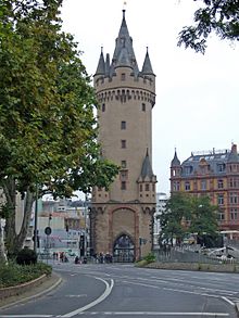
All parts of the fortification except the Sachsenhäuser Kuhhirtenturm and the Eschenheimer Turm were demolished; only a few gates from the 15th century at the Main river bank, including the Fahrtor, remained in place.
"[51] Rather wistfully, the younger Bettina von Arnim, already influenced by Romanticism, expressed herself: "Quite a few children of Frankfurt's citizens will have experienced the same as me, that to them, this is cold and eery, as if someone had sheared their wool in the middle of the winter.
Eight of the eleven historical bulwarks are still visible along the Anlagenring road; only the first demolished Galgenbollwerk and the two half bastions Fischerfeldbollwerk and Mainzer Bollwerk that had been located directly on the Main river bank have disappeared completely.
The houses between the Fronhofstrasse and the Wollgraben, and between the Fahrgasse and Hinter der schönen Aussicht, still show the 700-year-old position of the wall in their layout despite most of them having been rebuilt in classical style.