Four Corners Monument
These early surveys included some errors, but even so, the markers placed became the legal boundaries, superseding the written descriptions of geographical meridians and parallels.
[13] In 1860, just prior to the outbreak of the American Civil War, a group of people in the southern portion of New Mexico Territory passed a resolution condemning the United States for creating such a vast territory with only a single, small government in place at Santa Fe.
They claimed that by doing so, the U.S. had ignored the needs of the southern portion, left it without a functional system of law and order, and allowed the situation to deteriorate into a state of chaos and near-anarchy.
The Confederate boundaries split New Mexico along an east–west line, the 34th parallel north, allowing for a single state connection from Texas to the Colorado River.
The Union definition split New Mexico along a north-south line, the 32nd meridian west from Washington, which simply extended the boundary between Colorado and Utah southward.
[17] In 1875, another GLO surveyor, Chandler Robbins, surveyed and marked the border between the Arizona and New Mexico Territories (the 32nd meridian west of Washington).
[18][19] In 1878, Rollin J. Reeves surveyed and marked the border between the newly created State of Colorado and the Utah Territory.
Reeves located the sandstone shaft marker placed by Robbins at today's Four Corners Monument.
[20] By 1899, the sandstone shaft marker placed by Chandler Robbins in 1875 had been disturbed and broken, so it was replaced with a new stone by two U.S. surveyors, Hubert D. Page and James M. Lentz.
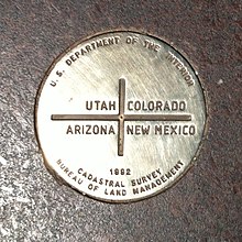
[6][21] In 1931, Everett H. Kimmell, another U.S. surveyor, found this newer stone had broken too, and he replaced it with a brass disc marker set in concrete.
[27] This issue resurfaced briefly in 2009 with U.S. media reports that the monument was placed 2.5 miles (4.0 km) west of its intended location.
The spokesperson, however, reiterated that the 1875 survey was accepted by all states and therefore its markers, including the Four Corners Monument, are legally binding.
[20] Similar statements were issued by the Navajo Nation, defending their work in maintaining and promoting the monument.
[18] From 2020 to 2021, the Four Corners Monument was closed to the public as part of Navajo Nation coronavirus safety regulations.