Four corners (Canada)
It is located by an area of marginal taiga forest, which happens to be the only place in Nunavut which is not Arctic tundra or ice cap.
[4][5] The crew worked from south to north along the Second Meridian as defined in the system of Dominion Land Surveys.
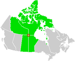
157, officially marked the intersection of the boundaries of Manitoba, Saskatchewan and the Northwest Territories.
[9] Specifically it decided that the first leg of the boundary should be a 472 km geodesic line running from Monument 157 to the first turning point at 64°14′N 102°00′W(NAD27).
[10] This decision confirmed that in the eyes of Natural Resources Canada, the two territories and two provinces do indeed meet at a quadripoint.