Cataracts of the Nile
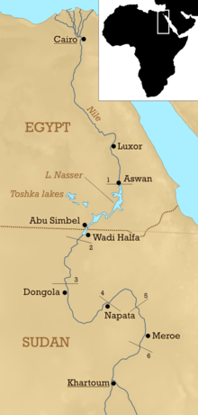
The Cataracts of the Nile are shallow lengths (or whitewater rapids) of the Nile river, between Khartoum and Aswan, where the surface of the water is broken by many small boulders and stones jutting out of the river bed, as well as many rocky islets.
[1] The Nubian Swell has diverted the river's course to the west, while keeping its depth shallow and causing the formation of the cataracts.
Despite these characteristics, some of the cataracts which are normally impassable by boat because of the shallow water have become navigable during the flood season.
[3] Besides the Kushite invasion, for most of Egyptian history, the Nile's cataracts, particularly the First Cataract, primarily served as a natural border to prevent most crossings from the south, as those in said region would rely on river travel to venture north and south.
[4] Eratosthenes gave a precise description of the Cataract-Nile:[5] It has a similar shape to a backwards letter N. It flows northward from Meroë about 2700 stadia, then turns back to the south and the winter sunset for about 3700 stadia, and it almost reaches the same parallel as the Meroë region and makes its way far into Libya.