Paulet–Newcombe Agreement
Britain's military occupied the region during the First World War, and in 1920, French Army invaded the Arab Kingdom of Syria.
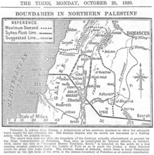
On 8 August 1920, during the Transjordan interregnum period, the French confirmed to the British that they would respect the Sykes-Picot line, and not move any military forces south.
[4] The boundary between the forthcoming British and French mandates was first defined in broad terms in the 1920 "Franco-British Convention on Certain Points Connected with the Mandates for Syria and the Lebanon, Palestine and Mesopotamia", signed in Paris by the British Ambassador to France, Charles Hardinge and the French Foreign Minister, Georges Leygues, on 23 December 1920.
[5] The 1932 commission concluded that the 1920 agreement had been reached on the basis of the “British International 1:1,000,000 map published in 1916 and revised in 1918”, formally known as the Asia 1: 1,000,000.
At Semakh the frontier will be fixed in such a manner as to allow each of the two High Contracting Parties to construct and establish a harbour and railway station giving free access to the Lake of Tiberias.
The amendments included:[8] It was approved with some caveats by the French and British governments on 7 March 1923, several months before Britain and France assumed their Mandatory responsibilities on 29 September 1923.