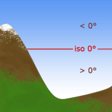
Freezing level
The freezing level, or 0 °C (zero-degree) isotherm, represents the altitude in which the temperature is at 0 °C (the freezing point of water) in a free atmosphere (i.e. allowing reflection of the sun by snow, icing conditions, etc.).
Any given measure is valid for only a short period of time, often less than a day as variations in wind, sunlight, air masses and other factors may change the level.
The profile of this frontier, and its variations, are studied in meteorology, and are used for a variety of forecasts and predictions, especially in cold weather.
There are several different methods to examine the structure of the temperature of the atmosphere including its freezing level: Depending on the frequency and resolution at which these readings are taken, these methods can report the isotherm with greater or lesser precision.
Weather radar can detect a variation every five to ten minutes if there is precipitation, and can scan a radius of up to two kilometers.