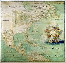
French colonization of Texas
In 1995, researchers located the ship La Belle in Matagorda Bay, with several sections of the hull remaining virtually intact.
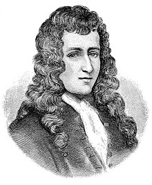
In 1681, French nobleman Robert Cavelier de La Salle launched an expedition down the Mississippi River from New France, at first believing he would find a path to the Pacific Ocean.
The colony could provide a base for promoting Christianity among the native peoples as well as a convenient location for attacking the Spanish province of Nueva Vizcaya and gaining control of its lucrative silver mines.
[2][5] He argued that a small number of Frenchmen could successfully invade New Spain by allying themselves with some of the more than 15,000 Native Americans who were angry over Spanish enslavement.
[2] He was to return to North America and confirm "the Indians' allegiance to the crown, leading them to the true faith, and maintaining intertribal peace".
[5] La Salle originally planned to sail to New France, journey overland to the south and Illinois Country, and then travel down the Mississippi River to its mouth.
[11] The ships carried a total of nearly 300 people, including soldiers, artisans and craftsmen, six Catholic missionaries, eight merchants, and over a dozen women and children.
[8][12] Shortly after their departure, France and Spain ceased hostilities, and Louis was no longer interested in sending La Salle further assistance.
Beaujeu sailed to another part of the island, allowing Spanish privateers to capture the St. François, which had been fully loaded with supplies, provisions, and tools for the colony.
[14] In late November 1684, when La Salle had fully recovered from a severe illness, the three remaining ships continued their search for the Mississippi River delta.
[13] Before they left Santo Domingo, local sailors warned that strong Gulf currents flowed east and would tug the ships toward the Florida straits unless they corrected for it.
[21] For several days the men attempted to salvage the tools and provisions that had been loaded on the Aimable, but a bad storm prevented them from recovering more than food, cannons, powder, and a small amount of the merchandise.
[24] Although Beaujeu delivered a message from La Salle requesting additional supplies, French authorities, having made peace with Spain, never responded.
[30] From January until March 1686, La Salle and most of his men searched overland for the Mississippi River, traveling towards the Rio Grande, possibly as far west as modern-day Langtry, Texas.
[31] During their travels, the group encountered the Caddo, who gave the Frenchmen a map depicting their territory, that of their neighbors, and the location of the Mississippi River.
[36] The destruction of their last ship left the settlers stranded on the Texas coast, with no hope of gaining assistance from the French colonies in the Caribbean Sea.
[35][37] La Salle believed that their only hope of survival lay in trekking overland to request assistance from New France,[36] and some time that month he led a final expedition to try to reach the Illinois Country.
[35] Fewer than 20 people remained at Fort Saint Louis, primarily women, children, and those deemed unfit, as well as seven soldiers and three missionaries with whom La Salle was unhappy.
They reached France in the summer of 1688 and informed King Louis of La Salle's death and the horrible conditions in the colony.
[39] Spanish pirate and guarda costa privateer Juan Corso had independently heard rumors of the colony as early as the Spring of 1685; he set out to eliminate the settlement but his ship was caught in rough seas and poor weather and was lost with all hands.
[40] Afterwards La Salle's mission had remained nearly secret until 1686 when former expedition member Denis Thomas, who had deserted in Santo Domingo, was arrested for piracy.
[41] The Spanish government felt the French colony would be a threat to their mines and shipping routes, and Carlos II's council of war thought that "Spain needed swift action 'to remove this thorn which has been thrust into the heart of America.
[42] Four Spanish expeditions the following year failed to find La Salle, but helped Spain to better understand the geography of the Gulf Coast region.
The land expedition, led by Alonso De León, discovered Jean Gery, who had deserted the French colony and was living in Southern Texas with the Coahuiltecans.
[49] France did not abandon its claims to Texas until November 3, 1762, when it ceded all of its territory west of the Mississippi River to Spain in the Treaty of Fontainebleau, following its defeat by Great Britain in the Seven Years' War.
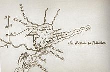
[52] In 1908, historian Herbert Eugene Bolton identified an area along Garcitas Creek, near Matagorda Bay, as the location of Fort St. Louis.
[53][54] Although several thousand items were recovered, archaeologists could not accurately distinguish between French and Spanish artifacts of the 17th century, and no report on the findings was ever issued.
[54] In late 1996, Keeran ranch workers exploring with metal detectors located eight cast-iron cannons buried near Garcitas Creek.
Researchers excavated a 792-pound (359 kg) cast-bronze cannon from the waters, as well as musket balls, bronze straight pins, and trade beads.
[59] Large sections of the wooden hull were intact, protected from the damaging effects of warm salt water by layers of muddy sediment which "essentially creat[ed] an oxygen-free time capsule".