GNSS augmentation
Using measurements from the ground stations, correction messages are created and sent to one or more satellites for broadcast to end users as differential signal.
Reference receivers in surveyed positions measure GPS deviations and calculate corrections emitted at 2 Hz through VHF data broadcast (VDB) within 23 nmi (43 km).
A GBAS can provide multiple approaches to reduce wake turbulence and improve resilience, maintaining availability and operations continuity.
[9] Among the 20 Honeywell GBAS installations worldwide, the other U.S. installations are: Honeywell's test facility in Johnson County, Kansas; the FAA Technical Center at Atlantic City International Airport, New Jersey; Boeing's test facility in Grant County, Washington; the B787 plant in Charleston International, South Carolina; and Anoka County–Blaine Airport near Minneapolis.
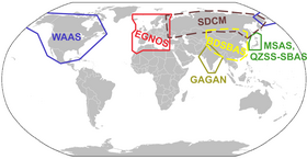
[9] In the US, GBAS was previously known as the Local-area augmentation system while a SBAS with a ground references network providing GPS corrections is called WAAS.
[9] The FAA's NextGen promotes GBAS and GLS to increase airport capacity and to lower noise and weather delays.
Some ICAO members vetter[clarification needed] GBAS Approach Service Types-D (GAST-D) supporting Cat.
[9] There are stricter Safety requirements on GBAS systems relative to SBAS systems since GBAS is intended mainly for the landing phase where real-time accuracy and signal integrity control is critical, especially when weather deteriorates to the extent that there is no visibility (CAT-I/II/III conditions) for which SBAS is not intended or suitable.
[11] Ground stations may also be used to accumulate continuous GNSS observations to achieve post-hoc correction of data to the centimeter level.
Many times the additional avionics operate via separate principles from the GNSS and are not necessarily subject to the same sources of error or interference.