Galloway Hills
The unusual place names reflect a mixture of the Old Norse and Scottish Gaelic languages and hint at the range of influences which have acted on society within the area over the centuries.
It follows the valley of Water of Minnoch[4] and for most of its length it passes through the extensive forestry plantations which lie to the west of the hills.
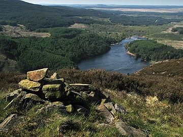
As mentioned above the heartland of the Galloway Hills lies to the north of Loch Trool and many excellent walks into that particularly wild remote territory start from the extensive car park by Bruce's Stone.
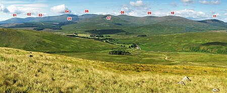
There are three ridges which run northwards from the Loch Trool/Loch Dee/Clatteringshaws area – The Awful Hand on the west, the Rhinns of Kells to the east, and the Dungeon Hills in between.
Taking the 'Awful Hand' from north to south are the following tops Shalloch on Minnoch, Tarfessock, Kirriereoch Hill, Merrick and Benyellary.
The Rhinns of Kells is 15.5 km as the crow flies from Black Craig to Darrou and the ridge has a double curve on it making it somewhat longer than that.
Craiglee is to an extent an outlier from the main ridge lying as it does at the eastern end of the Rig of the Jarkness which runs east to west.
A planning application was made in January 1978 to Kyle and Carrick District Council by the UKAEA to test drill on Mullwharchar for the purpose of dumping nuclear waste.
The sharp granite sand on the beaches of Loch Enoch itself was at one time collected and sold for sharpening knives and scythes.
Until around 1950 it was still in use as the home of a shepherd (or "Hird" in local parlance) working a part of the land known as the Dungeon of Buchan and was reckoned to be the loneliest such outpost in Galloway with the Silver Flowe to the west and the Rhinns of Kells to the east.
[18] The route Ralph Furlow would have used to cross the Rhinns was that used by the former residents of Back Hill – going over the saddle between Corserine and Millfire (OS.
There are the remains of several other former buildings scattered around the Galloway hills area; notably at Glenhead (NX433800) close to the Southern Upland Way for example, and at Culsharg (NX416822) on the "tourist route" from Bruce's Stone to the Merrick.
The Minnigaff Hills lie just south of the east end of Loch Trool and they stretch to the shores of Clatteringshaws Reservoir.
The battle which Bruce's Stone commemorates was actually fought (in 1307) at the south east end of Loch Trool where Muldonnoch falls steeply into it.
During World War II, Dumfries and several other places in south west Scotland were heavily involved in the training of pilots etc.
[23] Galloway was long regarded as a wild and lawless place – somewhat other from the mainstream of Scottish culture, which was as much as anything to do with its remoteness and inaccessibility.
The Galloway hills played an important part in this image especially as at various points in history it was a place of refuge for fugitives who did not fit into, or defied, the power structure of their times.
Robert the Bruce was crowned King of Scotland on 25 March 1306 little more than a month after he had been involved at Dumfries in the murder of John III Comyn, Lord of Badenoch, otherwise known as the Red Comyn, (a serious rival for the kingship of Scotland, as his mother was Eleanor Balliol who was the eldest daughter of John I de Balliol) .
He escaped to Rathlin Island off the Irish coast but by February 1307 he was back in Scotland, in the Galloway hills, with a tiny handful of followers and totally encircled by his enemies – a king hunted like an animal.
Though this was probably more of a minor skirmish in the guerrilla mode of William Wallace, it was important from a propaganda point of view in the recruitment of men to Bruce's cause.
He lived for some 3 months as a fugitive in these hills before he was able to break out of his confinement and go on eventually to the much more significant victory at Bannockburn in 1314 which gave Scotland some relief in the first War of Independence and the near subjugation to the English Crown which had ensued after the death of King Alexander III on 19 March 1286.
Robert the Bruce's brother Edward who was later to become High King of Ireland had long since carried out a successful campaign against the Comyn/Balliol faction in the south west of Scotland before Bannockburn.
Over a protracted period of time they were hunted in the hills of Galloway much as Bruce had been and were prepared to risk summary and brutal execution for their beliefs if caught.
Like the Bruce they were idealistic fugitives in the Galloway hills fighting for what they believed in and there were several battles between the covenanters and the crown forces in various parts of Scotland.
The 18th century was the heyday of smuggling along the Solway coast[27] – sitting as it does only around 20 miles (30 km) from the Isle of Man, the pathway for most contraband goods.
The Galloway hills offered a refuge for these far from idealistic lawless rogues and ruffians – somewhere to retreat to in times of trouble and as a safe route for the strings of up to 200 laden horses which carried their goods to Glasgow or Edinburgh.
"During the early 18th century Galloway was infested with gypsies, and it was no accident that Sir Walter Scott should have introduced Meg Merrilies and her tribe into his novel 'Guy Mannering' which is set in the Stewartry.
Scotland's National Bard Robert Burns was an excise man in eastern Galloway at the time of his death in 1796.