New Jersey Turnpike
The entire length of the New Jersey Turnpike is part of the National Highway System,[11] a network of roads important to the country's economy, defense, and mobility.
Upon entering Cherry Hill, the turnpike passes over tracks carrying the PATCO Speedline and NJ Transit's Atlantic City Line before reaching the Walt Whitman Service Area along the southbound lanes.
Still running within close proximity of I-295, the turnpike comes to a New Jersey State Police station and passes under Route 38 before crossing CSAO's Pemberton Industrial Track.
After the service areas, the turnpike enters Robbinsville Township and reaches an exit for I-195, an east–west freeway connecting the state capital of Trenton with the Jersey Shore.
North of here, the turnpike crosses the Millstone River into Cranbury Township, Middlesex County, and passes more warehouses on both sides of the road in addition to the southbound Molly Pitcher Service Area.
The highway then enters East Brunswick, where suburban development along the corridor greatly increases, indicating the entrance to the built-up portion of the New York metropolitan area.
[14] Continuing northeast, the turnpike passes under Amboy Avenue (Route 35) and crosses NJ Transit's North Jersey Coast Line.
North of I-78, the turnpike passes over CSAO's Chemical Coast Secondary, Greenville Running Track, and National Docks Branch at the Oak Island Yard.
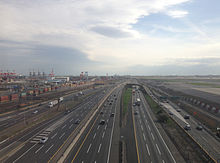
The NJTA refers to the complex series of roadways and ramps linking the car–truck lanes, the two spurs, as well as traffic heading to and from I-78 as the "Southern Mixing Bowl".
[17] Both spurs have an exit for US 1/9 Truck and pass under the Pulaski Skyway (US 1/9) at this point before crossing over CSAO's Passaic and Harsimus Line,[1][9] and will meet up at US 46 and I-80 to continue to the George Washington Bridge where the Turnpike will eventually end.
The bridge was named in honor of the three Lewandowski brothers, Army Private Alexander, Marine Sergeant Walter and Air Force Lieutenant William, who were killed in action during World War II within 18 months of each other.
[19] The turnpike then enters Secaucus and crosses the railroad right-of-way of the future Essex-Hudson Greenway and runs along the east side of Snake Hill.
After the southbound lanes have the Alexander Hamilton Service Area, the turnpike reaches the exit 18E toll plaza, serving as the northern end of the ticket system.
After passing over the New York, Susquehanna and Western Railway's New Jersey Subdivision line and CSX's River Subdivision line, the highway merges back together with the Western Spur as it passes east of PSE&G's Bergen Generating Station and crosses Overpeck Creek into Ridgefield Park, where the turnpike comes to its original northern terminus at US 46.
[25] The third extension, the four-mile (6.4 km) stretch of I-95 north of US 46 came under NJTA jurisdiction in 1992, as NJDOT sold the road to balance the state budget, and it is not tolled.
This section of the road – known as the I-95 Extension – extends the mainline to travel past the interchange for I-80 in Teaneck where the original terminus was, and through a cut in the Hudson Palisades to the George Washington Bridge Plaza in Fort Lee.
[32] In late March 2010, it was revealed that the state Transportation Commissioner was considering selling the naming rights of the rest areas to help address a budget shortfall.
The engineers decided to go through the residential area, since they considered it the grittiest[citation needed] and the closest route to both Newark Airport and the Port Newark–Elizabeth Marine Terminal seaport.
[42][43] As part of a 2005 seismic retrofit project, the NJTA lowered its roadway to increase vertical clearance and allow for full-width shoulders, which had been constrained by the location of the skyway supports.
The bridges were built to give motorists a clear view of the New York City skyline, but with high retaining walls to create the illusion of not being on a river crossing.
The purpose of this extension was to give motorists a "more direct bypass of the New York City area" to New England, by using the Tappan Zee Bridge.
The interchange would be constructed in order to provide direct connections to the nearby Newark Liberty International Airport, which had previously having required taking convoluted routes via exit 13 or 14.
The computer models allowed the court to understand the effects of roadway geometry, in this case width, vehicle speeds, proposed noise barriers, residential setback and pavement types.
[85] As part of this project, a new interchange with US 130 was built that was completed on December 17, 1999, replacing the old slip ramp in the area that fead onto local streets with many potholes.
[91] In order to address chronic congestion, the authority opened a new two lane ramp at exit 8A to carry traffic onto the newly extended CR 535 in February 2006.
The project, carried out in order to reduce truck traffic, involved constructing new elevated ramps from Roosevelt Avenue east to the toll gate, replacing what was previously a fully an at-grade interchange with a unidirectional one.
[96] In the middle of that year, the authority also reconstructed the Route 495 westbound overpass across the turnpike at exit 16E in Secaucus in order to add a third lane to said ramp.
[115][116][117][118] The authority planned to reconstruct exit 14A in Jersey City and its connectors in Bayonne because the interchange was in "poor condition" and suffered from chronic congestion.
Official groundbreaking occurred on March 11, 2015, with an expanded toll plaza and connector bridge targeted for completion in late 2018 with a $310 million budget.
Long term plans call to convert the road to an all electronic tolling system, where E-ZPass is supported and those who do not have it get a picture of their license plate taken and charged a bill later.