Geography
Geography (from Ancient Greek γεωγραφία geōgraphía; combining gê 'Earth' and gráphō 'write', literally 'Earth writing') is the study of the lands, features, inhabitants, and phenomena of Earth.
[22] Because space and place affect a variety of topics, such as economics, health, climate, plants, and animals, geography is highly interdisciplinary.
The interdisciplinary nature of the geographical approach depends on an attentiveness to the relationship between physical and human phenomena and their spatial patterns.
[25] Physical geography examines the natural environment and how organisms, climate, soil, water, and landforms produce and interact.
[28] In one attempt, the 1st edition of the book "Key Concepts in Geography" broke down this into chapters focusing on "Space," "Place," "Time," "Scale," and "Landscape.
Today, geographers are trained to recognize the world as a dynamic space where all processes interact and take place, rather than a static image on a map.
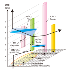
Time in geography is more than just the historical record of events that occurred at various discrete coordinates; but also includes modeling the dynamic movement of people, organisms, and things through space.
[43] Visualizing time over space is challenging in terms of cartography, and includes Space-Prism, advanced 3D geovisualizations, and animated maps.
[34] Physical geography is concerned with the study of processes and patterns in the natural environment like the atmosphere, hydrosphere, biosphere, and geosphere.
[34] Technical geography is interested in studying and applying techniques and methods to store, process, analyze, visualize, and use spatial data.
[64][65][66] It aims to understand the physical problems and the issues of lithosphere, hydrosphere, atmosphere, pedosphere, and global flora and fauna patterns (biosphere).
Its use dates back to 1749, when a book published by Edward Cave organized the discipline into a section containing content such as cartographic techniques and globes.
They must learn geodesy and fairly advanced mathematics to understand how the shape of the Earth affects the distortion of map symbols projected onto a flat surface for viewing.
[77] Remote sensing is the art, science, and technology of obtaining information about Earth's features from measurements made at a distance.
[80] Geostatistics is used extensively in a variety of fields, including hydrology, geology, petroleum exploration, weather analysis, urban planning, logistics, and epidemiology.
[82][17] An example of a form of qualitative cartography is a Chorochromatic map of nominal data, such as land cover or dominant language group in an area.
Geopoetics is an interdisciplinary approach that combines geography and poetry to explore the interconnectedness between humans, space, place, and the environment.
[90][91][92][93][94] Geographers employ interviews to gather data and acquire valuable understandings from individuals or groups regarding their encounters, outlooks, and opinions concerning spatial phenomena.
[48] Geographers typically adopt a structured or semi-structured approach during interviews involving specific questions or discussion points when utilized for research purposes.
[98] The ideas of Anaximander (c. 610–545 BC): considered by later Greek writers to be the true founder of geography, come to us through fragments quoted by his successors.
[104] The extensive mapping by the Romans as they explored new lands would later provide a high level of information for Ptolemy to construct detailed atlases.
[106] Chinese geographers such as Liu An, Pei Xiu, Jia Dan, Shen Kuo, Fan Chengda, Zhou Daguan, and Xu Xiake wrote important treatises, yet by the 17th century advanced ideas and methods of Western-style geography were adopted in China.
During the Middle Ages, the fall of the Roman empire led to a shift in the evolution of geography from Europe to the Islamic world.
Further, Islamic scholars translated and interpreted the earlier works of the Romans and the Greeks and established the House of Wisdom in Baghdad for this purpose.
He often combined astronomical readings and mathematical equations to develop methods of pin-pointing locations by recording degrees of latitude and longitude.
[111] The 18th and 19th centuries were the times when geography became recognized as a discrete academic discipline, and became part of a typical university curriculum in Europe (especially Paris and Berlin).
[115] The influence of Immanuel Kant, Alexander von Humboldt, Carl Ritter, and Paul Vidal de la Blache can be seen as a major turning point in geography from philosophy to an academic subject.
[121][122] Over the past two centuries, the advancements in technology with computers have led to the development of geomatics and new practices such as participant observation and geostatistics being incorporated into geography's portfolio of tools.
[130] The physical geographic features of a region, such as its landforms, climate, and resources, shape human settlements, trade routes, and economic activities, which in turn influence the course of historical events.
While the discipline of geography is normally concerned with the Earth, the term can also be informally used to describe the study of other worlds, such as the planets of the Solar System and even beyond.