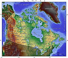
Geography of Canada
By land area alone, however, Canada ranks fourth, the difference being due to it having the world's largest proportion of fresh water lakes.
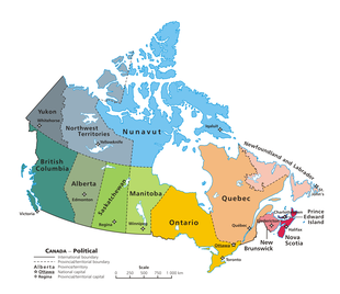
[3] Of Canada's thirteen provinces and territories, only two are landlocked (Alberta and Saskatchewan) while the other eleven all directly border one of three oceans.
Canada is home to the world's northernmost settlement, Canadian Forces Station Alert, on the northern tip of Ellesmere Island—latitude 82.5°N—which lies 817 kilometres (508 mi) from the North Pole.
[22] The Appalachian mountain range extends from Alabama in southern United States through the Gaspé Peninsula and the Atlantic Provinces, creating rolling hills indented by river valleys.
[25] The East Lowland includes Anticosti Island, Îles de Mingan, and extends to the Strait of Belle Isle.
The northeastern part of Alberta, northern parts of Saskatchewan, Manitoba, Ontario and Quebec, all of Labrador and the Great Northern Peninsula of Newfoundland, eastern mainland Northwest Territories, most of Nunavut's mainland and, of its Arctic Archipelago, Baffin Island and significant bands through Somerset, Southampton, Devon and Ellesmere islands are located on a vast rock base known as the Canadian Shield.
[26] The Shield mostly consists of eroded hilly terrain and contains many lakes and important rivers used for hydroelectric production, particularly in northern Quebec and Ontario.
[30] Physical or ecological aspects of the Canadian Prairies extend to northeastern British Columbia, but that area is not included in political use of the term.
[31] While the largest part of the Canadian Arctic is composed of seemingly endless permafrost and tundra north of the tree line, it encompasses geological regions of varying types: the Arctic Cordillera (with the British Empire Range and the United States Range on Ellesmere Island) contains the northernmost mountain system in the world.
[36] The Arctic, when defined as everything north of the tree line, covers most of Nunavut and the northernmost parts of Northwest Territories, Yukon, Manitoba, Ontario, Quebec and Labrador.
[37] Its southeastern end is separated from the North Cascades by the Fraser Lowland, where nearly a third of Western Canada's population reside.
The coastal flank of the Coast Mountains is characterized by an intense network of fjords and associated islands, very similar to the Norwegian coastline in Northern Europe; while their inland side transitions to the high plateau with dryland valleys notable for a series of large alpine lakes similar to those in southern Switzerland, beginning in deep mountains and ending in flatland.
[37] The terrain of the main spine of the Coast Mountains is typified by heavy glaciation, including several very large icefields of varying elevation.
The Coast Mountains are made of igneous and metamorphic rock from an episode of arc volcanism related to subduction of the Kula and Farallon Plates during the Laramide orogeny about 100 million years ago.
The Insular Mountains extend from Vancouver Island in the south to the Haida Gwaii in the north on the British Columbia Coast.
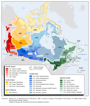
Many wide and slow-moving rivers flow through this area toward the saltwater of Hudson Bay: these include the Churchill, Nelson and Hayes in Manitoba, Severn, Fawn, Winisk, Asheweig, Ekwan, Attawapiskat, and Albany in Ontario, and the Harricana, Rupert and Eastmain in Quebec.
Winters can be harsh in many parts of the country, particularly in the interior and Prairie provinces, which experience a continental climate, where daily average temperatures are near −15 °C (5 °F), but can drop below −40 °C (−40 °F) with severe wind chills.
[54] Canada is divided into fifteen major terrestrial and five marine ecozones, that are further subdivided into 53 ecoprovinces, 194 ecoregions, and 1,027 ecodistricts.
[60] The Canadian Arctic tundra is the second-largest vegetation region in the country consisting of dwarf shrubs, sedges and grasses, mosses and lichens.
Though Canada's volcanic history dates back to the Precambrian eon, at least 3.11 billion years ago, when its part of the North American continent began to form,[62] volcanism continues to occur in Western and Northern Canada in modern times, where it forms part of an encircling chain of volcanoes and frequent earthquakes around the Pacific Ocean called the Pacific Ring of Fire.
[64] Even so, the mountainous landscapes of the Canadian provinces of Alberta, British Columbia, Yukon, and the Northwest Territories include more than 100 volcanoes that have been active during the past two million years and whose eruptions have claimed many lives.
[67] Canada is also home to about twenty five percent (134.6 million ha) of the world's wetlands that support a vast array of local ecosystems.
This basin is most important in fighting drought in the prairies and producing hydroelectricity, especially in Manitoba, northern Ontario and Quebec.
This watershed irrigates the agriculturally important areas of inner British Columbia (such as the Okanagan and Kootenay valleys), and is used to produce hydroelectricity.
Fossil fuels are a more recently developed resource in Canada, with oil and gas being extracted from deposits in the Western Canadian Sedimentary Basin since the mid-1900s.
In other forms, Canadian industry has a long history of extracting large coal and natural gas reserves.
Across the Canadian Shield and in the north there are large iron, nickel, zinc, copper, gold, lead, molybdenum, and uranium reserves.
Extensively developed in British Columbia, Ontario, Quebec and Labrador, the many dams have long provided a clean, dependable source of energy.
[76] The French islands of Saint Pierre and Miquelon lie off the southern coast of Newfoundland in the Gulf of St. Lawrence and have a maritime territorial enclave within Canada's exclusive economic zone.
Since the end of the Cold War, there has been growing speculation that Canada's Arctic maritime claims may become increasingly important if global warming melts the ice enough to open the Northwest Passage.