Geography of Kerala
The topography consists of a hot and wet coastal plain gradually rising in elevation to the high hills and mountains of the Western Ghats.
47'.40" N and east longitudes 74°.27'.47" E and 77°.37'.12" E.[2] Kerala's climate is mainly wet and maritime tropical,[3] heavily influenced by the seasonal heavy rains brought up by the monsoon Weather.
In summer, most of Kerala is prone to gale-force winds, storm surges, and torrential downpours accompanying dangerous cyclones coming in off the Indian Ocean.
A substantial portion of Malabar Coast including the western coastal lowlands and the plains of the midland may have been under the sea in ancient times.
[9] Pre-historical archaeological findings include dolmens of the Neolithic era in the Marayur area of the Idukki district, which lie on the eastern highland made by Western Ghats.
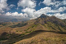
[10][11] Eastern Kerala consists of land encroached upon by the Western Ghats; the region thus includes high mountains, gorges, and deep-cut valleys.
The wildest lands are covered with dense forests, while other regions lie under tea and coffee plantations (established mainly in the 19th and 20th centuries) or other forms of cultivation.
Certain peaks may reach to 2500 m. Just west of the mountains lie the midland plains, comprising a swathe of land running along central Kerala.
[13] Finally, Kerala's coastal belt is relatively flat, teeming with paddy fields, groves of coconut trees, and heavily crisscrossed by a network of interconnected canals and rivers.
The comparative water-richness of the coastal belt can be partly gauged by the fact that Kuttanad, with its backwaters canals and rivers, itself comprises more than 20% of India's waterways by length.
It forms almost an unbroken wall guarding the eastern frontier and helps the people of Kerala to lead a sheltered life of their own through the centuries.
[18] Kerala is prone to several natural hazards, the most common of them being landslides, flooding, lightning, drought, coastal erosion, earthquakes, Tsunami, wind fall and epidemics.
The characteristic pattern of this phenomenon is the swift and sudden downslope movement of highly water saturated overburden containing a varied assemblage of debris material ranging in size from soil particles to boulders, destroying and carrying with it every thing that is lying in its path.
The west facing Western Ghats scarps that runs the entire extent of the mountain system is the most prone physiographic unit for landslides.
[21] The processes leading to landslides were accelerated by anthropogenic disturbances such as deforestation since the early 18th century, terracing and obstruction of ephemeral streams and cultivation of crops lacking capability to add root cohesion in steep slopes.
Studies conducted in the state indicates that prolonged and intense rainfall or more particularly a combination of the two and the resultant persistence and variations of pore pressure are the most important trigger of landslides.
A very recent study indicates that the additional cohesion provided by vegetation roots in soil is an important contributor to slope stability in the scarp faces of the Western Ghats of Kerala.
The human interventions contributing to flood problems are predominantly in the form of reclamation of wetlands and water bodies, change in land use pattern, construction of dense networks of roads, establishment of more and more settlements, deforestation in the upper catchments etc.
[19] Kerala is a place of high lightning incidence compared to most of the other parts in India because of its weather patterns and the location of the Western Ghats.
[19] Kerala has been experiencing increasing incidents of drought in the recent past due to the weather anomalies and developmental pressures resulting from the changes in land use, traditional practices, and life style of the people.
About 95 percent of annual rainfall is confined to a six-month monsoon period between June and November, leaving the remaining six months as practically dry.
With the implementation of a number of irrigation projects, the idea of drought in Kerala slowly shifted to unirrigated paddy, and upland crops.
As many as 6,280 dwelling units were completely destroyed, 11,175 were damaged and nearly 84,773 persons were evacuated from the coastal areas and accommodated in 142 relief camps after tsunami.