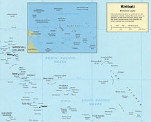
Geography of Kiribati
Kiribati consists of 32 atolls and one island in an expanse of ocean equivalent in size to the contiguous United States.
The islands of Kiribati lie roughly halfway between Hawaii and Australia in the Micronesian and Polynesian regions of the South Pacific.
On 1 January 1995 Kiribati moved the International Date Line to include its easternmost islands and make it the same day throughout the country.
A 1989 United Nations report identified Kiribati as one of the countries that could completely disappear in the 21st century if steps are not taken to address global climate change.
Kiribati has the 12th largest exclusive economic zone of 3,441,810 km2 (1,328,890 sq mi) (200 nautical miles).
On the island of Banaba, the British mined guano for phosphorus, until exhaustion of supply, an event that was before independence.
[13] It also signed conventions on the Climate Change-Kyoto Protocol, Desertification, Hazardous Wastes, Law of the Sea, Marine Dumping, Ozone Layer Protection.
[14] The Phoenix Islands Protected Area constitutes 11.34% of Kiribati's Exclusive Economic Zone (EEZ) with a size of 408,250 km2 (157,630 sq mi).