Geography of the Pitcairn Islands
Adamstown receives 1,543 millimetres (60.7 in) of rainfall annually, with the rain being evenly distributed across the year.
The climate of the Pitcairn Islands is modified by southeast trade winds.
The Pitcairn Islands have a rugged terrain caused by volcanic formation, with a rocky coastline and cliffs.
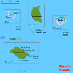
Lowest point: Pacific Ocean coastline 0 m (sea level) Highest point: Pawala Valley Ridge 347 m (1,138 ft) Miro trees (used for handicrafts), fish Note: manganese, iron, copper, gold, silver, and zinc have been discovered offshore Tropical Cyclones (especially November to May) Deforestation (only a small portion of the original forest remains because of burning and clearing for settlement) Download coordinates as: Worldwide map services show very little detail of the islands, and are even of limited use to show the location of them with respect to each other and to other islands, because they are so small and far apart.
However, Mapquest zoom level 1 is a suitable map to see the location between Peru and New Zealand.