Geography of Indonesia
[12] The outer arc of Nusa Tenggara is a geological extension of the chain of islands west of Sumatra that includes Nias, Mentawai, and Enggano.
They are located in the northeast sector of the archipelago, bounded by the Philippine Sea to the north, Papua to the east, and Nusa Tenggara to the southwest.
The largest of these islands include Halmahera, Seram and Buru, all of which rise steeply out of very deep seas and have unique Wallacea vegetation.
[16][17] Geomorphologists believe that the island of New Guinea is part of the Australian continent, both lies on Sahul Shelf and once joined via a land bridge during the Last glacial period.
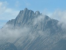
[18][19] The tectonic movement of the Australian plate created towering, snowcapped mountain peaks lining the island's central east–west spine and hot, humid alluvial plains along the coasts.
[21][22] Most of the larger islands are mountainous, with peaks ranging between 2,000 and 3,800 metres (6,562 and 12,467 ft) meters above sea level in Sumatra, Java, Bali, Lombok, Sulawesi, and Seram.
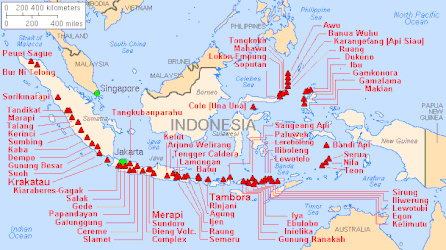
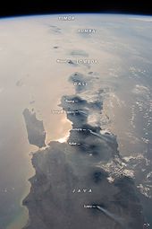
A string of volcanoes stretches from Sumatra to Nusa Tenggara,[24] and then loops around through to the Banda Islands of Maluku to northeastern Sulawesi.
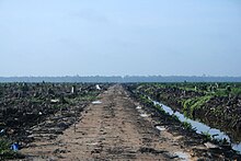
While volcanic ashes resulted from eruption has positive effects for the fertility of the surrounding soils, it also makes agricultural conditions unpredictable in some areas.
[28] The 2004 Indian Ocean earthquake and tsunami devastated the Indonesian provinces of Aceh and North Sumatra, resulting in approximately 225,000 deaths and leaving over 425,000 people homeless.
The Indonesian government, in partnership with international organizations like the IMF, World Bank, and ADB, coordinated relief and reconstruction efforts.
During a donor meeting in January 2005, nearly $4 billion in aid was pledged for reconstruction, with a focus on transparency and efficient fund management.
The Paris Club also offered a temporary debt moratorium, which helped fund rebuilding without diverting domestic financial resources.
[30] Northern Maluku and western New Guinea is located on the convergence of Bird's Head, Philippine Sea and Caroline plate.
The almost uniformly warm waters that make up 81% of Indonesia's area ensure that temperatures on land remain fairly constant.
Winds are moderate and generally predictable, with monsoons usually blowing in from the south and east in June through October and from the northwest in November through March.
Typhoons and large scale storms pose little hazard to mariners in Indonesia waters; the major danger comes from swift currents in channels, such as the Lombok and Sape straits.
[39] Issues include large-scale deforestation (much of it illegal) and related wildfires causing heavy smog over parts of western Indonesia, Malaysia and Singapore; over-exploitation of marine resources; and environmental problems associated with rapid urbanisation and economic development, including air pollution, traffic congestion, garbage management, and reliable water and waste water services.
One cultural pattern consists of the formerly Indianized, rice-growing peasants in the valleys and plains of Sumatra, Java, and Bali, another cultural complex is composed of the largely Islamic coastal commercial sector, a third, more marginal sector consists of the upland forest farming communities which exist by means of subsistence swidden agriculture.
To some degree, these patterns can be linked to the geographical resources themselves, with abundant shoreline, generally calm seas, and steady winds favouring the use of sailing vessels, and fertile valleys and plains—at least in the Greater Sunda Islands—permitting irrigated rice farming.
The heavily forested, mountainous interior hinders overland communication by road or river, but fosters slash-and-burn agriculture.