Historic Ladakh consists of a number of distinct areas (mainly under Indian rule), including the fairly populous main Indus valley, the more remote Zanskar (in the south) and Nubra valleys (to the north over Khardung La in the Ladakh mountain range, a high motorable pass at 5,359 metres (17,582 ft)), the almost deserted Aksai Chin (under Chinese rule) and the predominantly Shi'ite Muslim Kargil and Suru valley areas in the west (Kargil being the second most important town in Ladakh).
Historically populated by the Ladakhi people, continued immigration and preferential treatment to Kashmiris by the J&K government have led to demographic changes in the Ladakh region.
The Baltistan and Skardu area, under Pakistani rule and entirely Muslim, used to be included in what is geographically referred to as Ladakh.
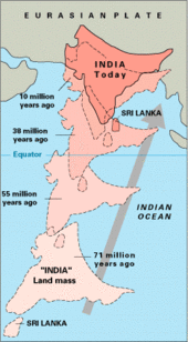
The mountain ranges in this region were formed over a period of 45 million years by the folding of the Indian Plate into the stationary landmass of Asia.
South-east of Zoji-la the scale increases, reaching a climax in the mighty massif of Nun-Kun, with two summits over 7000 m. The enormous mass of the Himalayas creates a rain shadow, denying entry to the moisture-laden clouds of the Indian monsoon.
The regions on the north flank of the Himalayas—Dras, the Suru valley and Zanskar—experience heavy snowfall and remain virtually cut off from the rest of the country for several months in the year.
The 6,000-kilometre-plus (3,700 mi) journey of the India landmass (Indian Plate) before its collision with Asia (Eurasian Plate) about 40 to 50 million
years ago
.
[
1
]
Map-R3: Changchenmo River Valley. The Changchenmo originates in east near
Lanak La
, flows in China-held area till
Konka La
and thereafter in the India-held area via
Tsogstsalu
& Hot Springs to its confluence with Shyok River on
Darbuk–Shyok–DBO Road
(DSDBO Road). Its tributary Kugrang River flows NW-SE entirely within India-held area from Chang-lung La (Changlung La/Pass) and confluences at India-held Hot Springs. Kugrang River's tributary Changlung River flows NE-SW within China-held India-claimed area from Chang-lung Barma La (Changlung Barma La/Pass) and confluences at Gogra pasture (unmarked). (Survey of India, 1916).
Map-R4: The "Depsang Bulge" with China's 1960 claim line to the right and its claim of the "Line of Actual Control" in 2020 to the left.
[
a
]
Burtsa Nala flows E-W via Y-junction, Tiannan Gap, Indian Military Post near west of Y-junction to India's Burtsa Patrol Base on
DSDBO Road
where it confluences with its north to south flowing tributary Depsang Nala and then turns south; flows 4 km to Burtsa Yogma pasture caravan camping ground; then turns west & flows 15 km to its confluences with NW-SE flowing
Murgo Nala
; after that it flows 9 km southeast to its confluence with Jeong Nala, then flows 7 km south to its confluence at
Colonel Chewang Rinchen Bridge
(CCR Bridge) near Sultan Chushku caravan camp with NW-SE flowing Shyok River coming from
Sasser La
direction.