Geography of Queensland
It includes tropical islands, sandy beaches, flat river plains that flood after monsoon rains, tracts of rough, elevated terrain, dry deserts, rich agricultural belts and densely populated urban areas.
The total land mass of Queensland covers 22.5% of the Australian continent, an area of 1,729,742 square kilometres, making it the second largest state in Australia.
The Tropic of Capricorn crosses the state with about half of Queensland's area located to the north of the line.
[5] These rare lakes, which total 80 of this type worldwide, are formed in depressions between sand dunes and have no natural inflow or outflow.
North West Island is a coral cay that sustains important nesting grounds for sea birds and turtles.
The Great Sandy Strait is a passage extending south of Hervey Bay, between the mainland and Fraser Island.
There are a few natural lakes created by volcanic craters and coastal lagoons mainly in South East Queensland.
Wallaman Falls west of Ingham in North Queensland is Australia's largest single drop waterfall.
Eastern Queensland is dominated by the Great Dividing Range in contrast to the low-relief of western areas.
East of the Great Dividing Range is a narrow coastal strip, known as the Australian north-east coast drainage division which contains most of the state's population.
It is along this strip that the state's most important agricultural product, sugar cane, is grown in the fertile soils and moist climate.
The Bunya Mountains an isolated spur of the Great Divide are especially scenic and provide important habitat in a region that has suffered from excess land clearing.
Closer to the coast is the Glasshouse Mountains, a series of volcanic plugs which were named by the explorer Captain James Cook.
Elevated areas in the south-eastern inland can experience temperatures well below freezing in mid-winter providing frost and, rarely, snowfall.
[12] There are six predominant climatic zones in Queensland,[13] based on temperature and humidity: The annual mean climatic statistics[14] for selected Queensland cities are shown below: The coastal far north of the state is the wettest region in Australia, with Mount Bellenden Ker, south of Cairns, holding many Australian rainfall records with its annual average rainfall of over 8 metres.
[22] Severe springtime thunderstorms generally affect the south-east and inland of the state and can bring damaging winds, torrential rain, large hail and even tornadoes.
Queensland has the highest average maximums of any Australian state, and Stanthorpe, Hervey Bay, Mackay, Atherton, Weipa and Thursday Island are the only large population centres not to have recorded a temperature above 40 °C (104 °F).
In the central regions of the state are the cities of Rockhampton, Bundaberg, Gladstone with its economically important coal exporting port facilities, Maryborough and Hervey Bay.
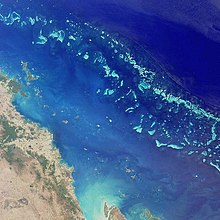
World Heritage Areas include the Great Barrier Reef, Wet Tropics of Queensland and Gondwana Rainforests of Australia.
Further afield is the Carnarvon National Park in Central Queensland containing rugged gorge country and some of Australia's finest Aboriginal rock art.