Geography of Vermont
The Green Mountains in Vermont form a north–south spine running most of the length of the state, slightly west of its center.
The state's geographic center is approximately three miles (5 km) east of Roxbury, in Washington County.
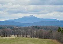
Several mountains have timberlines with delicate year-round alpine ecosystems, including Mount Mansfield, the highest mountain in the state; Killington Peak, the second-highest; Camel's Hump, the state's third-highest; and Mount Abraham, the fifth-highest peak.
[8] Vermont has a humid continental climate, with muddy springs, in general a mild early summer, hot Augusts; it has colorful autumns: Vermont's hills reveal red, orange, and (on sugar maples) gold foliage as cold weather approaches.
[11] The rural northeastern section known as the "Northeast Kingdom" often averages 10 °F (5.6 °C) colder than the southern areas of the state during winter.
The state is already seeing effects of climate change that affect its ecosystems, economy and public health.
It is the site of the limestone Fisk Quarry, which contains a collection of ancient marine fossils, such as stromatoporoids, that date to 200 million years ago.
[51] Vermont contains one species of venomous snake, the timber rattlesnake, which is confined to a few acres in western Rutland County.
[54] Since 1970, reduction of farmland has resulted in reduced environment for, and resulted in a decline in numbers of various shrubland birds, including the American woodcock, brown thrasher, eastern towhee, willow flycatcher, golden-winged warbler, blue-winged warbler, field sparrow, and Baltimore oriole.
[55] Ospreys, whose eggs were previously damaged by DDT, began to reappear in 1998 and by 2010 were no longer endangered in the state.
[59][60] Invasive species and organisms include the Asian spotted-wing drosophila, a destroyer of crops,[61] and eastern equine encephalitis virus whose antibodies were found in moose or deer in each of Vermont's counties.
Much of the state, in particular the Green Mountains, is covered by the conifers and northern hardwoods of the New England-Acadian forests.
The southwest corner of the state and parts of the Connecticut River are covered by northeastern coastal forests of mixed oak.
[63] Invasive wild honeysuckle has been deemed a threat to the state's forests, native species of plants, and wildlife.
[citation needed] Climate change appears to be affecting the maple sugar industry.
Sugar maples have been subject to stress by acid rain, asian longhorn beetles, and pear thrips.
In 2011, the deer herd had grown too large for habitat, and many resorted to eating bark to survive the winter, destroying trees in the process.