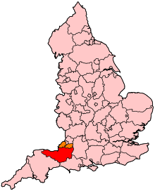
Geology of Somerset
They make up a sequence of lavas, tuffs (volcanic ash), shales and mudstones in a narrow outcrop to the northeast of Shepton Mallet, in the eastern Mendip Hills.
[1] Rocks from the Devonian (419–359 million years ago) are found across much of Exmoor,[2] the Quantocks (including Hangman Sandstone and Cockercombe tuff), and in the cores of the folded masses of the Mendip Hills.
The limestones are very fossiliferous, and contain evidence of the abundant marine life that existed at the time of their creation, including fossil crinoids (sea-lilies), corals and brachiopods.
At the end of the Permian (299–252 million years ago) and Triassic periods, the Variscan orogeny resulted in the formation of several mountainous areas including Dartmoor in the south, Exmoor and the Quantocks, and the Mendips.
In the Taunton area Permian (299–252 million years ago) red sandstones and breccia outcrop, although rocks of Triassic age (252–201 million years ago) underlie much of Somerset and form the solid geology of the Somerset Moors and Levels.
[7] In prehistoric times the coastline of Somerset was very different from the present one, the sea level at the last glacial maximum being several hundred feet lower than today so that the Bristol Channel was almost non-existent.
[7] The coastline contains exposures of Devonian sediments and tectonics west of Minehead adjoining the classic exposures of Mesozoic sediments and structural features which extend eastward to the Parrett estuary[13] forming cliffs along the coastline near Clevedon and near Minehead,[14] with low sandhills near Burnham-on-Sea.
It passes to the east of South Petherton and flows north through Thorney Moor and Muchelney Level and it is then joined by the Isle and Yeo (Ivel) rivers.
These wetlands cover 600 square kilometres (232 sq mi), most of which is no higher than 8 metres (26 ft) above sea level.
Carboniferous Limestone, of marine origin, covers the sandstone and appears in the Avon Gorge and at Weston-super-Mare where it contains volcanic rocks.
Further east there are Silurian volcanoes, Carboniferous Limestone outcrops, Variscan thrust tectonics, Permo-Triassic conglomerates, sediment-filled fissures, a classic unconformity, Jurassic clays and limestones, Cretaceous Greensand and chalk topped with Tertiary remnants including Sarsen Stones.
These sediments have yielded a fairly rich fossil fauna of brachiopods and trilobites indicating that they were deposited in a shallow marine sea into which the lavas were extruded.
[39] Coal measures appear in the Radstock district, and surrounding Somerset Coalfield (largely concealed by Triassic and newer rocks).
This was one of the first areas in the world to undergo systematic geological study and mapping by John Strachey and William Smith in the 18th century.
[41][42] They observed the rock layers, or strata, which led Smith to the creation of a testable hypothesis, which he termed the Principle of Faunal Succession.
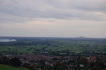
[45] To the south of Somerset there is an upland with a series of rolling valleys and scarps, from Penselwood in the east to the Blackdown Hills, another designated Area of Outstanding Natural Beauty, in the west.
[21] The Quantock Hills are a 20 kilometres (12 mi) long broad ridge from the coast near Watchet in the north to near Taunton in the south.
They reach 384 metres (1,260 ft) high at Wills Neck and are separated from Exmoor and the Brendons by a rift valley.
The Quantocks and the Brendon Hills at the eastern end of Exmoor are formed by thick sequences of slates and sandstones of Devonian age that were deposited by large deltas that built out into a shallow sea.
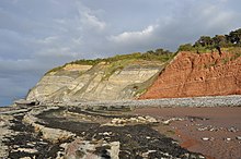
[50] The lower fringes around the hills are composed of younger rocks of the Triassic period,[53] these are known as New Red Sandstone rocks which represent the deposits of large river systems that crossed a desert plain,[3] and often contain irregular masses or veins of gypsum, which was worked on the foreshore at Watchet.
[25] Several areas have outcrops of slates and between St Audries and Kilve, younger rocks of the Jurassic Period can be found.
This area falls within the Blue Anchor to Lilstock Site of Special Scientific Interest (SSSI) and is considered to be of international geological importance.
[54] At Kilve are the remains of a red brick retort, built in 1924, when it was discovered that the shale found in the cliffs was rich in oil.
[56] Exmoor is a dissected plateau of Devonian sedimentary rock, rising to 517 metres (1,696 ft) at Dunkery Beacon.
Because of high rainfall there are boggy areas and the part by the Chains is a Geological Conservation Review site recognised as being nationally important for its south-western lowland heath communities and for transitions from ancient semi-natural woodland through upland heath to blanket mire.
The Chains provides palynological record of a mid to late Flandrian vegetation history on Exmoor.
[64] Exmoor has 55 kilometres (34 mi) of coastline, including the highest cliffs in England, which reach a height of 1,350 feet (411 m) at Culbone Hill.
[68] The Exmoor Coastal Heaths have been recognised as a Site of Special Scientific Interest due to the diversity of plant species present.
The action of streams has cut combes through the hills down to the sea, which are now wooded, although much of Exmoor is open heathland.
The Brendon Hills are an eastern outlier of Exmoor with the same undulating landscape but separated from the main area by the valley of the River Avill.