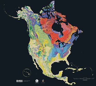
Geology of North America
The Canadian Shield is a large area of Archean through Proterozoic igneous and metamorphic rocks in eastern Canada and north central and northeastern United States.
[4] The exposed sections are often where glaciers have removed this overlying regolith to reveal the underlying glacially scarred crystalline rock.
[citation needed] The sea receded as the continent rose becoming covered by stream, lake, and wind deposits.
[7] One billion years ago, the Midcontinent Rift System began to extend along a 2,000 kilometres (1,200 mi) path,[10] across both the Canadian Shield and the Stable Platform.
[14] North of this fold and thrust belt, the Acadian Orogen of the middle Devonian is an area where deformation has exposed granite plutons.
[19] During the Taconic orogeny 445 to 435 million years ago, accretion continued, an island arc collided with the North American continent, and mountains were raised.
[20] The eastern portion of the orogen is made up of the Piedmont plateau, a 150 to 300 metres (490 to 980 ft) elevation area composed of Paleozoic marine and volcanic sediments deformed into crystalline metamorphic rocks and intruded by granite domes.
[21] During the Proterozoic a series of terranes were accreted onto the North American craton, forming the Piedmont of the central Appalachians.
[23] The bedrock of the plateau formed about 470 million years ago during the Taconic orogeny, when a volcanic island arc collided with the ancestral North American Continent.
Terranes were no longer accreted onto the margin; instead, sediment eroded off the Appalachians began to be deposited on the coast, forming a coastal plain and continental shelf.
As the basement subsided, sediment accumulated, during the Mesozoic and Cenozoic, forming the modern wedge, containing salt basins.
It includes the Cascades, Sierra Nevada, and Basin and Range province; the Rocky Mountains are sometimes excluded from the cordillera proper, in spite of their tectonic history.
The breakup of Pangea 200 million years ago began the westward movement of the North American plate, creating an active margin on the western continent.
[36] The lithology of the Rocky Mountains in western Canada includes a thin-skinned fold and thrust belt involving Neoproterozoic through Mississippian series of carbonates, shales, argillites and sandstones.
[40] The Basin and Range Province is a series of linear block fault mountains with adjacent sediment-filled downfaulted valleys, having been caused by crustal extension around 17 million years ago.
[32] Other Mesozoic terranes that accreted onto the continent include the Klamath Mountains, the Sierra Nevada, and the Guerrero super-terrane of western Mexico.
[42] As the Laramide Orogeny ended around 48 million years ago, the accretion of the Siletzia terrane began in the Pacific Northwest.
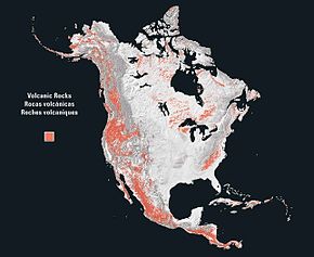
This began the volcanic activity in the Cascadia subduction zone, forming the modern Cascade Range, and lasted into the Miocene.
As extension in the Basin and Range Province slowed by a change in North American Plate movement circa 7 to 8 Million years ago, rifting began on the Gulf of California.
[43] The Sierra Madre mountain ranges of Mexico are separated by the Mexican Plateau, and transected by the Trans-Mexican Volcanic Belt.