Geology of Scotland
This part of Scotland largely comprises ancient rocks, from Cambrian and Precambrian times, that were uplifted to form a mountain chain during the later Caledonian orogeny.
The Hebridean archipelago outlier of St Kilda is composed of Palaeogene igneous formations of granites and gabbro, heavily weathered by the elements.
This area has also experienced intense volcanism, Arthur's Seat in Edinburgh being the remnant of a once much larger volcano active in the Carboniferous period about 340 million years ago.
[13][14] In the post-glacial epoch, circa 6100 BC, Scotland and the Faroe Islands experienced tsunamis up to 20 metres high caused by the Storegga Slides, a series of immense underwater landslides off the coast of Norway.
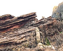
[18] These rocks are largely igneous in origin, mixed with metamorphosed marble, quartzite and mica schist and intruded by later basaltic dykes and granite magma.
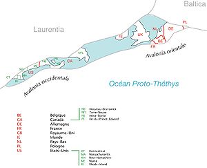
Nonetheless, northern and southern Britain were far apart at the beginning of this period, although the gap began to close as the continent of Avalonia broke away from Gondwana, collided with Baltica and drifted towards Laurentia.
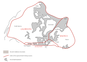
Sea levels rose as the Ordovician ice sheets melted, and tectonic movements created major faults which assembled the outline of Scotland from previously scattered fragments.
The accumulations of Old Red Sandstone laid down from 408 to 370 million years ago were created as earlier Silurian rocks, uplifted by the formation of Pangaea, eroded and were deposited into a body of fresh water (probably a series of large river deltas).
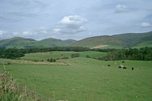
In Scotland these rocks are found predominantly in the Moray Firth basin and Orkney Archipelago, and along the southern margins of the Highland Boundary Fault.
During the Triassic (252–201 Ma), much of Scotland remained in desert conditions, with higher ground in the Highlands and Southern Uplands providing sediment to the surrounding basins via flash floods.
[36] As the Jurassic (201–145 Ma) started, Pangaea began to break up into two continents, Gondwana and Laurasia, marking the beginning of the separation of Scotland and North America.
Most of northern and eastern Scotland including Orkney, Shetland and the Outer Hebrides remained above the advancing seas, but the south and south-west were inundated.
There are only isolated sedimentary rocks remaining on land from this period, on the Sutherland coast near Golspie and, forming the Great Estuarine Group, on Skye, Mull, Raasay and Eigg.
Although large deposits of Cretaceous rocks were laid down over Scotland, these have not survived erosion except in a few places on the west coast such as Loch Aline in Morvern[39][40] where they form a part of the Inner Hebrides Group.
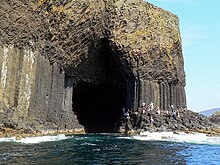
This led to a chain of volcanic sites west of mainland Scotland including on Skye, the Small Isles and St. Kilda, in the Firth of Clyde on Arran and Ailsa Craig and at Ardnamurchan.
[43] At the beginning of this period the climate was sub-tropical and erosion was caused by chemical weathering, creating characteristic features of the Scottish landscape such as the topographical basin of the Howe of Alford near Aberdeen.
[44][46] Several ice ages shaped the land through glacial erosion, creating u-shaped valleys and depositing boulder clays, especially on the western seaboard.
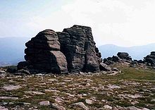
The last major incursion of ice peaked about 18,000 years ago, leaving other remnant features such at the granite tors on the Cairngorm mountain plateaux.
[51] A rare type of Scottish coastline found largely in the Hebrides consists of machair habitat,[52] a low lying dune pasture land formed as the sea level dropped leaving a raised beach.
Younger Carboniferous rocks lie unconformably over the top of them, dipping gently, indicating that an enormous span of time must have passed between the creation of the two beds.
When Hutton and James Hall visited the site in 1788 their companion Playfair wrote:[10][68] The Moine Thrust in Assynt is one of the most studied geological features in the world.
[28] Investigations by John Horne and Benjamin Peach resolved a dispute between Murchison and Geikie on the one hand and James Nicol and Charles Lapworth on the other.
[73] Lapworth also had a prominent role to play in the fame of Dob's Linn, a small gorge in the Scottish Borders, which contains the 'golden spike' (i.e. the official international boundary or stratotype) between the Ordovician and Silurian periods.
Lapworth's work in this area, especially his examination of the complex stratigraphy of the Silurian rocks by comparing fossil graptolites, was crucial in to the early understanding of these epochs.
The Skye Cuillin mountains provide classic examples of glacial topography and were the subject of an early published account by James Forbes in 1846 (who had become a fellow of the Royal Society of Edinburgh aged only nineteen).
[78][79] In the hills to the north of the village of Strontian the mineral strontianite was discovered, from which the element strontium was first isolated by Sir Humphry Davy in 1808.
The bulk of this fossil bed consists of primitive plants that had water-conducting cells and sporangia but no leaves, along with arthropods: Collembola, Opiliones (harvestmen), pseudoscorpions and the extinct, spider-like Trigonotarbids.