Geology of the Tasman District
The Greenland Group rocks form the base, and are composed of sandstones and mudstones deposited in a submarine fan environment (Late Cambrian-early Ordovician, 505-470 Ma).
Later (Late Cambrian-Early Devonian, 500-397 Ma, mostly eastern) rocks were deposited in a passive margin environment, and include the Mount Arthur limestone and marble.
The Riwaka Complex intruded rocks on the west of Abel Tasman National Park, south to the Baton River Area.
The Separation Point Suite corresponds to the granite rocks from Abel Tasman National Park, south to Springs Junction.
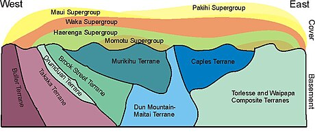
The Eastern Province Brook Street, Murihiku, and Dun Mountain-Maitai Central Arc terranes form narrow successively more easterly strips to the east of the Waimea-Flaxmore Fault System, running from Durville Island in the north, to the Alpine Fault near Nelson Lakes in the south.
The Brook Street terrane corresponds to a Permian (300-250 Ma) oceanic island arc, and contains well-preserved cross sections through volcanic cones.
The Murihiku terrane is composed of Triassic to Jurassic (250-145 Ma), relatively undeformed marine sandstone, derived from a volcanic arc.
The rocks are mostly sandstone and argillite, deposited in a submarine fan, adjacent to an island arc, which have been metamorphosed to schist close to the boundary with the Rakaia terrane in the southeast.
The rocks to the south of the Alpine Fault belong to the Torlesse composite terrane (Rakaia to the west of Nelson Lakes, Pahau to the east).
The rocks around Picton–Arapawa Island are thought to belong to the Morrinsville terrane, and are late Triassic (227–206 Ma) sandstone that has been metamorphosed into schist.
The rocks of western Nelson used to be adjacent to those in Fiordland and Central Otago, before the Alpine Fault was activated in the Early Miocene (23 Ma).
The land then sank, the sea transgressed, and calcareous sandstone, mudstone, and limestone were deposited in Oligocene times (34-24 Ma).
The Alpine Fault developed in Early Miocene times (23 Ma), uplift occurred, and deposition changed from limestone to mudstone.
Large quantities of Torlesse derived gravel were generated from the Southern Alps, and are preserved in the Moutere Depression.
Abel Tasman National Park is of interest for limestone and marble, Separation Point granite, and the Riwaka Complex diorite and gabbro.
From the top of the park, it is possible to see Harwoods Hole, a large vertical shaft that goes down to the limestone cave system of Takaka Hill.
[needs update] Low resolution versions of these maps (without the associated booklet) can be downloaded from the GNS site for free.