Geology of the Zion and Kolob canyons area
These sediments later lithified (turned to rock) to form the Toroweap Formation, now exposed in the Grand Canyon to the south but not in the Zion and Kolob area.
In later Permian time, the Toroweap Basin was invaded by the warm, shallow edge of the vast Panthalassa ocean in what local geologists call the Kaibab Sea.
[5] During this time, sponges, such as Actinocoelia meandrina, proliferated, only to be buried in lime mud and their internal silica needles (spicules) dissolved and recrystallized to form discontinuous layers of light-colored chert.
As the sea withdrew around 230 million years ago, fluvial, mudflat, sabkha, and shallow marine environments developed, depositing gypsum (from lagoon evaporites), mudstones, limestones, sandstones, shales, and siltstones.
Unlike the Timpoweap and Virgin Limestone members, the Shnabkaib contains abundant gypsum and interbedded mudstone resulting from deposition in a restricted marine environment with complex watertable fluctuations.
Ripple marks, mud cracks, and thinly laminated bedding suggest that these intervening red shale and siltstone units were deposited in tidal flat and coastalplain environments.
Later, uplift exposed the Moenkopi Formation to erosion and Utah became part of a large interior basin drained by north and northwest-flowing rivers in the Upper Triassic.
[6] Petrified wood and fossils of animals adapted to swampy environments, such as phytosaurs, lungfish, and lacustrine bivalves, have been found in this formation as well as conifer trees, cycads, ferns, and horsetails.
The purple, pink, blue, white, yellow, gray, and red colored Chinle also contains shale, gypsum, limestone, sandstone, and quartz.
The sand, gravel, and petrified wood which made up these deposits were later strongly cemented by dissolved silica (probably from volcanic ash from the west) in groundwater.
The lowermost member of the Chinle, the Shinarump, consists of a white, gray, and brown conglomerate made of coarse sandstone, and thin lenses of sandy mudstone, along with plentiful petrified wood.
[6] A succession of volcanic-ash-rich mudstone and sandstone with a thickness of 350-foot (110 m) make up the Petrified Forest Member of the Chinle, which was deposited by lakes, highly sinuous rivers and on the surrounding floodplains.
[3] At 200 to 600 feet (61 to 183 m) thick, the Kayenta Formation's sand and silt were laid down in early Jurassic time in slower-moving, intermittent streambeds in a semiarid to tropical environment.
[7] Interbedded sandstone, basal conglomerates, siltstones, mudstones, and thin cross-beds are typical channel and floodplain deposits found in the Kayenta.
Approximately 190 to 136 million years ago[13] in the Jurassic the Colorado Plateau area's climate increasingly became arid until 150,000 square miles (388,000 km2) of western North America became a huge desert, not unlike the modern Sahara.
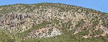
[7] Today the Navajo Sandstone is a geographically widespread, pale tan to red cliff and monolith former with very obvious sand dune cross-bedding patterns (photo).
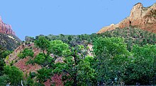
Springs, such as Weeping Rock (photo), form in canyon walls made of the porous Navajo Sandstone when water hits and is channeled by the underlying non-porous Kayenta Formation.
Broad tidal flats and streams carrying iron oxide-rich mud formed on the margins of the shallow sea to the west, creating the Sinawava member of the Temple Cap Formation.
Desert conditions returned briefly, creating the White Throne member, but encroaching seas again beveled the coastline, forming a regional unconformity.
A warm, shallow inland sea started to advance into the region (transgress) 150 million years ago, finishing the job of flattening the sand dunes.
Some calcareous silt percolated down into the buried sand dunes (carrying red oxides with it) and eventually cemented them into the sandstone of the Navajo Formation.
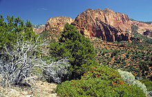
[12] Outcrops of the Carmel Formation are most notably exposed on Horse Ranch Mountain[16] (photo) in the Kolob Canyons section of the park and near Mt.
Mountains continued to rise in the Sevier orogenic belt to the west during the Cretaceous while the roughly north-south trending Western Interior Basin expanded.
[17] The western shoreline of the seaway was in the vicinity of Cedar City, Utah, while the eastern margin was part of the low-lying, stable platform ramp in Nebraska and Kansas.
East–west-directed compression from subduction off the west coast affected the area in later Mesozoic and early Tertiary time by folding and thrust faulting strata.
[22] Downcutting continues to be especially rapid after heavy rainstorms and winter runoff when the water contains large amounts of suspended and abrasive sand grains.
Explosive andesitic volcanism dominated the area to the west of Zion during Oligocene and early Miocene time and probably inundated the region with hundreds of feet of welded tuff that has since eroded away.
Then from at least 1.4 million to 250,000 years ago in Pleistocene time basaltic lava flowed intermittently in the area, taking advantage of uplift-created weaknesses in the Earth's crust.
[23] The lava traveled into Coalpits and Scoggins Washes to the south and accumulated to a depth of over 400 ft (122 m) in the ancestral Virgin River valley near the present-day ghost town of Grafton, Utah.
Stream downcutting continued along with canyon-forming processes such as mass wasting; sediment-rich and abrasive flood stage waters would undermine cliffs until vertical slabs of rock sheared away.