Georgetown (Washington, D.C.)
Georgetown was an independent municipality until 1871 when the United States Congress created a new consolidated government for the entire District of Columbia.
In 1632, English fur trader Henry Fleet documented an American Indian village of the Nacotchtank people called Tohoga on the site of present-day Georgetown and established trade there.
[citation needed] George Washington frequented Georgetown, including Suter's Tavern, where he negotiated many deals to acquire land for the new national capital.
[12] Stoddert and other Potomac landowners agreed to a land transfer deal to the federal government at a dinner at Forrest's home in Georgetown on March 28, 1791.
The speculative purchases were not, however, profitable and caused Stoddert much difficulty before his appointment as Secretary of the Navy by John Adams, the nation's second president.
The municipal governments of Georgetown and the City and County of Washington were formally revoked by Congress effective June 1, 1871, at which point its governmental powers were vested within the District of Columbia.
[17] Congress abolished ownership of slaves in the entire District on April 16, 1862, annually observed today as Emancipation Day.
[19] By the late 19th century, flour milling and other industries in Georgetown were declining, in part due to the fact that the canals and other waterways continually silted up.
Abert led efforts to dredge the channels and remove rocks around the Georgetown harbor, though these were temporary solutions and Congress showed little interest in the issue.
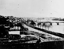
[21] An 1890 flood and expansion of the railroads brought destitution to the C&O Canal, and Georgetown's waterfront became more industrialized, with narrow alleys, warehouses, and apartment dwellings which lacked plumbing or electricity.
[25] In 1915, the Buffalo Bridge on present-day Q Street opened and connected this part of Georgetown with the rest of the city east of Rock Creek Park.
In the early 1920s, John Ihlder led efforts to take advantage of new zoning laws to get restrictions enacted on construction in Georgetown.
In 1949, the city constructed the Whitehurst Freeway, an elevated highway above K Street, to allow motorists entering the District over the Key Bridge to bypass Georgetown entirely on their way downtown.
[28] The law required that the United States Commission of Fine Arts be consulted on any alteration, demolition, or building construction within the historic district.
Much of Georgetown is surrounded by parkland and green space that serve as buffers from development in adjacent neighborhoods, and provide recreation.
The primary commercial corridors of Georgetown are M Street and Wisconsin Avenue, whose high fashion stores draw large numbers of tourists as well as local shoppers year-round.
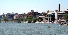
There is also the Washington Harbour complex on K Street, on the waterfront, featuring outdoor bars and restaurants popular for viewing boat races.
Between M and K Streets runs the historic Chesapeake and Ohio Canal, today plied only by tour boats; adjacent trails are popular with joggers or strollers.
[39] The main campus is just over 102 acres (41 ha) in area and includes 58 buildings, student residences capable of accommodating 80 percent of undergraduates, various athletic facilities, and the medical school.
Campus green areas include fountains, a cemetery, large clusters of flowers, groves of trees, and open quadrangles.
[40] The main campus has traditionally centered on Dahlgren Quadrangle, although Red Square has replaced it as the focus of student life.
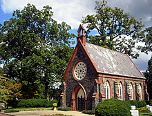
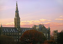
[41] Healy Hall, built in Flemish Romanesque style from 1877 to 1879, is the architectural gem of Georgetown's campus, and is a National Historic Landmark.
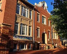
An earlier public library in Georgetown was endowed by financier George Peabody in 1867 and opened in a room of the Curtis School on O Street opposite St. John's Church in 1875.
[45] A newly constructed, climate-controlled third floor now houses the collections of the original Peabody Library and is a center for research on Georgetown history.
Wisconsin Avenue is on the alignment of the tobacco hogshead rolling road from rural Maryland, and the Federal Customs House was located on 31st Street (now utilized as the post office).
Five suburban Virginia lines, connecting in Rosslyn, provided links from the Washington, D.C. streetcar network to Arlington National Cemetery, Fort Myer, Nauck, Alexandria, Mount Vernon, Clarendon, Ballston, Falls Church, Vienna, Fairfax, Leesburg, Bluemont, and Great Falls (see Northern Virginia trolleys).
In 1910, the Baltimore and Ohio Railroad completed an 11-mile branch line from Silver Spring, Maryland, to Water Street in Georgetown in an abortive attempt to construct a southern connection to Alexandria, Virginia.
[50] The abandoned right-of-way has since been converted into the Capital Crescent Trail, a rails-to-trails route,[50] and the power plant replaced by a condo.
The planners expected the Metro to serve rush-hour commuters, and the neighborhood has few apartments, office buildings, or automobile parking areas.
Three stations are located roughly one mile (1.6 km) from the center of Georgetown: Rosslyn (across the Key Bridge in Arlington), Foggy Bottom-GWU, and Dupont Circle.