North Sea
Download coordinates as: The North Sea lies between Great Britain, Denmark, Norway, Germany, the Netherlands, Belgium, and France.
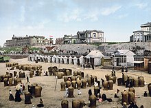
The coast is a popular destination for recreation and tourism in bordering countries, and a rich source of energy resources, including wind and wave power.
The North Sea has featured prominently in geopolitical and military affairs, particularly in Northern Europe, from the Middle Ages to the modern era.
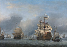
The Hanseatic League, the Dutch Republic, and Britain all sought to gain command of the North Sea and access to the world's markets and resources.
In the north, deep fjords and sheer cliffs mark much of its Norwegian and Scottish coastlines respectively, whereas in the south, the coast consists mainly of sandy beaches, estuaries of long rivers and wide mudflats.
Adverse environmental issues – commonly including overfishing, industrial and agricultural runoff, dredging, and dumping, among others – have led to several efforts to prevent degradation and to safeguard long-term economic benefits.
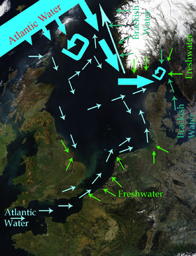
[1][2] In the east, it connects to the Baltic Sea via the Skagerrak and Kattegat,[2] narrow straits that separate Denmark from Norway and Sweden respectively.
[4] The salinity has the highest variability where there is fresh water inflow, such as at the Rhine and Elbe estuaries, the Baltic Sea exit and along the coast of Norway.
From north east of England, the cliffs become lower and are composed of less resistant moraine, which erodes more easily, so that the coasts have more rounded contours.
[68] Storm surges threaten, in particular, the coasts of the Netherlands, Belgium, Germany, and Denmark and low-lying areas of eastern England particularly around The Wash and Fens.
[61] Storm surges are caused by changes in barometric pressure combined with strong wind created wave action.
The rifting that formed the northern part of the Atlantic Ocean during the Jurassic and Cretaceous periods, from about 150 million years ago, caused tectonic uplift in the British Isles.
[82] The North Sea was cut off from the English Channel by a narrow land bridge until that was breached by at least two catastrophic floods between 450,000 and 180,000 years ago.
Cod, haddock, whiting, saithe, plaice, sole, mackerel, herring, pouting, sprat, and sandeel are all very common and are fished commercially.
[93] Similarly, sea grass used to coat huge tracts of ocean floor, but have been damaged by trawling and dredging have diminished its habitat and prevented its return.
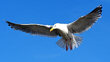
[95] Due to the heavy human populations and high level of industrialization along its shores, the wildlife of the North Sea has suffered from pollution, overhunting, and overfishing.
[97] Grey whales also resided in the North Sea but were driven to extinction in the Atlantic in the 17th century[98] Other species have dramatically declined in population, though they are still found.
[102] All North Sea border states are signatories of the MARPOL 73/78 Accords, which preserve the marine environment by preventing pollution from ships.
[108] Other common names in use for long periods were the Latin terms Mare Frisicum, as well as the English equivalent, "Frisian Sea".
[115] As the League lost control of its maritime cities, new trade routes emerged that provided Europe with Asian, American, and African goods.
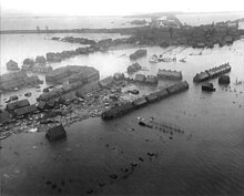
[122] Britain's larger fleet and North Sea Mine Barrage were able to establish an effective blockade for most of the war, which restricted the Central Powers' access to many crucial resources.
However, it gained significant economic importance in the 1960s as the states around the North Sea began full-scale exploitation of its oil and gas resources.
[131] Countries that border the North Sea all claim the 12 nautical miles (22 km; 14 mi) of territorial waters, within which they have exclusive fishing rights.
[133] After the discovery of mineral resources in the North Sea during the early 1960s, the Convention on the Continental Shelf established country rights largely divided along the median line.
[134] The ocean floor border between Germany, the Netherlands, and Denmark was only reapportioned in 1969 after protracted negotiations and a judgment of the International Court of Justice.
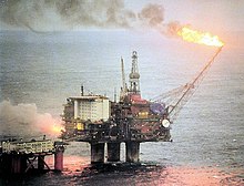
[142] The North Sea contains western Europe's largest oil and natural gas reserves and is one of the world's key non-OPEC producing regions.
Industry body Oil & Gas UK put the decline down to rising costs, lower production, high tax rates, and less exploration.
[145] The British North Sea's oil and gas production, peaking in 2000, had declined by 2024, while offshore wind projects like Dogger Bank grew to support renewable energy goals, with windfall taxes funding the transition.
[149] In recent decades, overfishing has left many fisheries unproductive, disturbing marine food chain dynamics and costing jobs in the fishing industry.
In addition to oil, gas, and fish, the states along the North Sea also take millions of cubic metres per year of sand and gravel from the ocean floor.
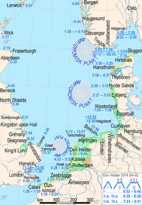
• Tide times after Bergen (negative = before)
• The three amphidromic centers
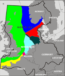
• Coasts:
marshes = green
mudflats = greenish blue
lagoons = bright blue
dunes = yellow
sea dikes= purple
moraines near the coast= light brown
rock-based coasts = greyish brown