Gertrud Rask Land
[1][2] The territory was named by Lauge Koch after Gertrud Rask (1673 – 1735), the wife of missionary Hans Egede, during the 1921–1923 Bicentenary Jubilee Expedition surveys.
Koch found no muskoxen in the area and deemed that it was too arduous for the animals to cross this barren, inhospitable expanse, so that they had to choose another route to reach the northeast coast of Peary Land in their migrations.
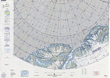
To the south rise the highest peaks of the Roosevelt Range, including Helvetia Tinde.
[5][1] The terrain is harsh, mountainous and rugged, with numerous glaciated areas.
The highest point of Gertrud Rask Land is a 1,432 metres (4,698 ft) summit located in the inner part.