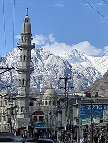
Gilgit
Gilgit (/ˈɡɪlɡɪt/; Shina: گلیٗت; Urdu: گلگت IPA: [ˈɡɪlɡɪt]) is a city in Pakistani-administered Gilgit–Baltistan in the disputed Kashmir region.
[5] Brokpas trace their settlement from Gilgit into the fertile villages of Ladakh through a rich corpus of hymns, songs, and folklore that have been passed down through generations.
[9] They are believed to have been the Patola Shahis dynasty mentioned in a Brahmi inscription,[10] and are devout adherents of Vajrayana Buddhism.
[11] In mid-600s, Gilgit came under Chinese suzerainty after the fall of the Western Turkic Khaganate to the Tang military campaigns in the region.
Chinese records of the region continue until late the 700s, at which time the Tangs' western military campaign was weakened due to the An Lushan Rebellion.
They cover a wide range of themes such as iconometry, folk tales, philosophy, medicine and several related areas of life and general knowledge.
As of 6 October 2014, one source claims that the part of the collection deposited at the Sri Pratap Singh Museum in Srinagar was irrecoverably destroyed during the 2014 India–Pakistan floods.
Tradition relates that he was killed by a Mohammedan adventurer, who married his daughter and founded a new dynasty, since called Trakhàn, from a celebrated Ra named Trakhan, who reigned about the commencement of the fourteenth century.
They claim descent from a heroic Kayani Prince of Persia, Azur Jamshid (also known as Shamsher), who secretly married the daughter of the king Shri Badat.
[29] In the beginning of the new year, where a Juniper procession walks along the river, in memory of chasing the cannibal king Sri Badat away.
According to tradition, Shri Buddutt's rule extended over Chitral, Yassin, Tangir, Darel, Chilas, Gor, Astor, Hunza, Nagar and Haramosh all of which were held by tributary princes of the same family.
[22]The area had been a flourishing tract but prosperity was destroyed by warfare over the next fifty years, and by the great flood of 1841 in which the river Indus was blocked by a landslip below the Hatu Pir and the valley was turned into a lake.
Then in 1842, Shah Sakandar's brother, Karim Khan, expelled Yasin rulers with the support of a Sikh army from Kashmir.
Gilgit fell to the Hunza and their Yasin and Punial allies but was soon reconquered by Gulab Singh's Dogra troops.
[33] In 1877, in order to guard against the advance of Russia, the British India Government, acting as the suzerain power of the princely state of Jammu and Kashmir, established the Gilgit Agency.
It comprised the Gilgit Wazarat; the State of Hunza and Nagar; the Punial Jagir; the Governorships of Yasin, Kuh-Ghizr and Ishkoman, and Chilas.
Abdullah Sahib was the first Muslim governor of the Gilgit in British time period and was close associate of Maharaja Partap Singh.
Justice Muhammad Yusuf Saraf, at the time a Muslim Conference activist, has pointed out that such a major operation could not have been launched without Jinnah's knowledge and approval.
"[38][page needed] The military leaders of the Frontier Districts Province (modern day Gilgit-Baltistan) wanted to join Pakistan.
[39] Sensing their discontent, Major William Brown, the Maharaja's commander of the Gilgit Scouts, mutinied on 1 November 1947, overthrowing the Governor Ghansara Singh.
[40] The bloodless coup d'etat was planned by Brown to the last detail under the code name "Datta Khel", which was also joined by a rebellious section of the Jammu and Kashmir 6th Infantry under Mirza Hassan Khan.
The Gilgit rebellion did not have civilian involvement and was solely the work of military leaders, not all of whom had been in favor of joining Pakistan, at least in the short term.
[42] According to various scholars, the people of Gilgit as well as those of Chilas, Koh Ghizr, Ishkoman, Yasin, Punial, Hunza and Nagar joined Pakistan by choice.
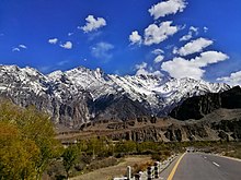
Weather conditions for Gilgit are dominated by its geographical location, a valley in a mountainous area, southwest of Karakoram range.
Gilgit lacks significant rainfall, averaging in 120 to 240 mm (4.7 to 9.4 in) annually, as monsoon breaks against the southern range of Himalayas.
Long-term plans for the China–Pakistan Economic Corridor call for construction of the 682 km (424 mi) long Khunjerab Railway, which is expected to be completed in 2030,[53] that would also serve Gilgit.