Glacier Bay Basin
[1][2][3][4][5] The Glacier Bay has many branches, inlets, lagoons, islands, and channels that holds prospects for scientific exploration and visual treat.
[7] The earliest recorded history of the Glacier Bay area starts with the 1741 Russian expedition of Vitus Bering and Aleksei Chirikov.
[9] In 1794, Joseph Whidbey, master of the Discovery during George Vancouver's 1791–95 expedition, reported that his exploration of this part of the coast was blocked by a wall of 2 miles (3.2 km) width and 1,200 metres (3,900 feet)) thick.
The United States purchased Alaska from the Russians in 1867 with a claim under that treaty of owning all lands up to "the summit of the mountains situated parallel to the coast".
The arbitration award given in 1903 resolved the Alaska boundary dispute by drawing a line that linked the mountain peaks in this area.
John Muir and his friend Harriman who were members of this expedition were instrumental in governmental lobbying on National Park legislation says.
[12] John Muir was seeking corroboration of the continental glaciation theories of Louis Agassiz, whose controversial Etudes sur les Glaciers was published in 1840.
The preserve, which is a spectacular ensemble of marine and terrestrial life, is delimited by: The Tongass National Forest borders on the east and north east; by the international boundary with Tatshenshini-Alsek Wilderness Provincial Park in British Columbia, Canada on the north; by the waters of Cross Sound and Icy Strait border on the south; and by the Pacific Ocean on the west.
[14] When President Calvin Coolidge declared the Glacial Bay to be a national monument, in 1925, the objective clearly stated was: a number of tidewater glaciers ... in a magnificent setting of lofty peaks ... ; a great variety of forest covering consisting of mature areas, bodies of youthful trees which have become established since the retreat of the ice which should be preserved in absolutely natural condition, and great stretches now bare that will become forested in the course of the next century; a unique opportunity for the scientific study of glacial behavior and of resulting movements and developments of flora and fauna and of certain valuable relics of interglacial forests; historic interest, having been visited by explorers and scientists since the early voyages of Vancouver in 1794 who left valuable records of such visits and explorations.
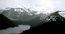
[9] The Glacier Bay Basin is now a myriad combination of tidewater glaciers, snow-capped mountain ranges, ocean coastlines, deep fjords, and freshwater rivers and lakes that provide widely varying land and seascape and "hosts a mosaic of plant communities and a variety of marine and terrestrial wildlife.
[16] Post Little Ice Age Rebound in the Glacier Bay Basin has been studied by researchers of the Geophysical Institute, University of Alaska Fairbanks, Alaska in association with National Park and Preserve Service, under a National Science Foundation grant using GPS geodesy combined with studies of raised shorelines and tide gauges.
The studies have also reported that "these adjustments to LIA loading and unloading are producing significant stresses on the earth's crust which can affect seismicity and regional tectonics.
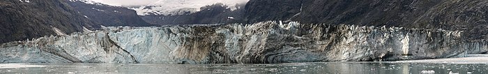
Calving is a process in which blocks of ice get detached or break off from the glacier, irrespective of weather conditions, all the year round, and crash into the sea with thundering noise creating a boiling like turbulence.
[4] Three climatic zones have been discerned in the Glacier Bay; the outer coast along the Gulf of Alaska, which records mild temperatures and higher precipitation.
[4] The environment of Glacier Bay has been categorized under four main land ecosystems namely, the wet tundra, the coastal western hemlock/Sitka spruce forest, the alpine tundra, and the glaciers and ice fields; within the Bay proper, further break up into three major marine ecosystems are marked namely, "within in and around continental shelf, wave-beaten coasts, and fjord estuaries.
[7][20] Humpback whales have been sighted in the lower region of Glacier Bay; also in Sitakaday Narrows, Whidbey Passage and the waters around South Marble Island.
For kayakers, Hugh Miller Inlet and the Beardslee Islands are good locations to see humpback whales from a safe distance of about a quarter mile.
These include: the bald eagle, golden eagle, raven, northern hawk owl, sandhill crane, loon, Steller's jay, murre, cormorant, puffin, murrelet, oystercatchers, herons, geese, ducks, ptarmigan, crow, osprey, blue grouse, woodpecker, pigeon guillemot, sparrow, sandpiper, plover, Arctic tern, kittiwake and gulls.
[2] Fish species found in the bay are: Chinook, chum, sockeye, pink and coho salmon, halibut, trout, steelhead, Dolly Varden, lingcod, whitefish, blackfish, char and herring.
Some of the major inlets, glaciers and the mountains in the order of their location from the entry have been identified from the National Park Service Map.
Further, during this process of retreat, glacial till left behind two large deltas extending to a width of about 1,400 feet (430 m) at the water edge during low tide.
[26] Johns Hopkins Inlet is closed to boats in May and June in order to protect unweaned harbor seal pups.
[27] The Johns Hopkins Glacier rises from the Fairweather Range on the east slopes of Lituya Mountain and Mount Salisbury and has an easterly flow towards the head of Johns Hopkins Inlet, 1 mile (1.6 km) southwest of the terminus of Clark Glacier and 79 miles (127 km) northwest of Hoonah.
[16][26] The Johns Hopkins Glacier, for example, cannot be approached any nearer than about 2 miles (3.2 km) by sea because of the volume of the ice blocks that break loose from its cliffs.
The west shore line of this inlet is steep and rocky, extends to 4 miles (6.4 km) up to a small stream where a beach has been formed.
The Grand Pacific Glacier, at the head of the Tarr Inlet on the north, has a streaked face covered with gravel and stones (more than 3 feet (0.91 m)) thick in many areas).
Landslides and medial moraines cover much of eastern side of the glacier extending to about two-thirds width of the ice face.
In the earlier 18th century, it was a one single block of ice at the Gulf of Alaska, when Captain Vancouver first saw it, which has receded to the present location that is 65 miles (105 km)) from the Glacier Bay inlet.
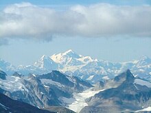
[32] Between the bay and the coast, snow-clad peaks of the Fairweather Range capture the moisture coming in off the Gulf of Alaska and, in turn, spawn the park's largest glaciers.
While most of the mountain lies within the City and Borough of Yakutat, the summit is also in Tatshenshini-Alsek Provincial Park, British Columbia (Canada), making it the highest point in that province.