Glamorgan
Archaeologist Stephen Aldhouse-Green notes that while Wales has a "multitude" of Mesolithic sites, their settlements were "focused on the coastal plains", the uplands were "exploited only by specialist hunting groups".
[5][9][10] Human lifestyles in North-West Europe changed around 6000 BP; from the Mesolithic nomadic lives of hunting and gathering, to the Neolithic agrarian life of agriculture and settlement.
These megalithic burial chambers, or cromlechi, were built between 6000 and 5000 BP, during the early Neolithic period, the first of them about 1500 years before either Stonehenge or the Egyptian Great Pyramid of Giza was completed.
Other technological innovations – including the wheel; harnessing oxen; weaving textiles; brewing alcohol; and skillful metalworking (producing new weapons and tools, and fine gold decoration and jewellery, such as brooches and torcs) – changed people's everyday lives during this period.
By 4000 BP people had begun to bury, or cremate their dead in individual cists, beneath a mound of earth known as a round barrow; sometimes with a distinctive style of finely decorated pottery – like those at Llanharry (discovered 1929) and at Llandaff (1991) – that gave rise to the Early Bronze Age being described as Beaker culture.
[38] By virtue of its location and geography, Morgannwg or Glywysing was the second part of Wales, after Gwent, to fall under the control of the Normans and was frequently the scene of fighting between the Marcher Lords and Welsh princes.
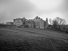
The earliest surviving structures within the region are early stone monuments, waypoints and grave markers dating between the 5th and 7th century, with many being moved from their original position to sheltered locations for protection.
Major families in Glamorgan included the Carnes at Ewenny, the Mansels at Margam, Williams of Neath, the Herberts at Cardiff and Swansea, Sir David Ap Mathew of Llandaff, and the Stradlings of St Donats.
[50] Although copper had been mined in Wales since the Bronze Age, it was not until non-ferrous metalworking became a major industry in the late 17th century that Glamorgan saw a concentration of works appearing in a belt between Kidwelly and Port Talbot.
John Leland mentions a works at Llantrisant in 1539, an operation in Aberdare existed during the reign of Edward VI and two iron furnaces were recorded as being set up by Sir W. Mathew in Radyr during the Elizabethan era.
[48] By the 17th century, the availability of fine building stone permitted the construction of high-quality lime-washed rural cottages and farmhouses in the Vale of Glamorgan, which drew favourable remarks from travellers.
[57] The industry was developed by English entrepreneurs and investors such as John Henry Vivian[58] and largely based in the west of the county, where coal could be purchased cheaply and ores imported from Cornwall, Devon and later much further afield.
Ironmaking developed in locations where ironstone, coal and limestone were found in close proximity – primarily the northern and south-western parts of the South Wales coalfield.
[71] The industrial period of Glamorgan saw a massive building program throughout the uplands and in the coastal regions, reflecting the increasing population and the need for new cheap housing to accommodate the hundreds of thousands of workers coming into the area.
The period saw the appearance, not only of the works and pits themselves, but of the terrace house or miners cottage, railway stations, hospitals, churches, chapels, bridges, viaducts, stadiums, schools, universities, museums and workingmen's halls.
[72] In 1897, Cardiff Corporation acquired land from the Marquess of Bute with the intention of erecting buildings to meet the administrative, legal and educational needs of Glamorgan's county town.
From 1901 onwards, Cathays Park was developed into "possibly the finest... civic centre in Britain" with a range of public buildings including the Baroque City Hall and the rococo-style University College.
Coal mining eventually became the dominant industry in Glamorgan and tall winding towers – originally made of timber or cast iron, later steel – became symbolic icons.
[77] Several factors came together to cause this collapse, including the over-valuation of sterling, the end of the coal subsidy, the growth of electric power,[78] the adoption of oil as the fuel of choice for many industries, and over-expansion of the mines in the late nineteenth century.
Other parts of Britain began to recover as domestic demand for consumer products picked up, but unemployment in the South Wales Valleys continued to rise: the jobless rate in Merthyr reached 47.5 per cent in June 1935.
Initially built for tubercular patients, whose cure required the maximum amount of light and air,[86] the functional architecture left a striking glass-fronted building, completed in 1936.
To the south east is a gently undulating limestone plateau,[90] virtually coterminous with the modern county borough of Vale of Glamorgan, mainly comprising farmland and small villages stretching from Porthcawl to Cardiff.
[90] In the 19th century, industrial and population growth in the coal-bearing valleys of the Rhymney, Taff, Dare and Rhondda gave rise to a form of urbanisation characterised as ribbon development.
[91] The high ground that runs centrally through the Gower was largely uncultivated common land and its beaches and rocky coastal headlands showed little signs of the tourist trade[91] that played an increasing role on the local economy.
[97] South easterly from Lavernock Point, roughly three miles out in the Channel Estuary is Flat Holm, an island which although geographically is within the Vale, is administered as part of the city of Cardiff.
Two miles beyond, the Ogmore River runs out into a sand-locked bay which can be seen as commencing the second section of the Glamorgan coast,[100] as here the scenery undergoes an abrupt change; from a series of unbroken cliffs to vast regions of sandy beaches.
[101] The coast continues to the north west as a low rocky formation for three miles to Sker Point, after which the sand line begins again, forming an arid wilderness all the way to Port Talbot.
[113][114] In 1935, a Royal Commission argued that Merthyr Tydfil County Borough, then heavily burdened by the cost of maintaining many unemployed people, should be abolished and merged with Glamorgan.
The motto adopted by the county council: A Ddioddefws A Orfu or 'He Who suffered, conquered' was that of the lineage of Iestyn ap Gwrgant, and was considered appropriate to an area whose wealth depended on great hardship.
[152] These towns, most notably Barry Island, Porthcawl, Aberavon and Mumbles, owed their existence as tourist locations to the development of the south Wales coal field and the introduction of the workers' annual holidays.


(The modern border with England is also shown)


Click on map to enlarge
