Glastonbury Tor
The iron-rich waters of Chalice Well, a spring at the base of the Tor, flow out as an artesian well impregnating the sandstone around it with iron oxides that have reinforced it to produce the caprock.
[17] This optical phenomenon occurs because rays of light are strongly bent when they pass through air layers of different temperatures in a steep thermal inversion where an atmospheric duct has formed.
They may have been formed as a result of natural differentiation of the layers of Lias stone and clay or used by farmers during the Middle Ages as terraced hills to make ploughing for crops easier.
[23] Iron Age hill forts including the nearby Cadbury Castle in Somerset show evidence of extensive fortification of their slopes.
South Cadbury, one of the most extensively fortified places in early Britain, had three concentric rings of banks and ditches supporting an 44-acre (18 ha) enclosure.
It has been suggested by Ralegh Radford that it is part of a great Celtic sanctuary, probably 3rd century BC, while others, including Philip Rahtz, date it to the post-Roman period and link it to the Dark Age occupation on Glastonbury Tor.
[28] The historian Ronald Hutton also mentions the alternative possibility that the terraces are the remains of a medieval "spiral walkway" created for pilgrims to reach the church on the summit,[29] similar to that at Whitby Abbey.
He states that the classical labyrinth (Caerdroia), a design found all over the Neolithic world, can be easily transposed onto the Tor so that by walking around the terraces a person eventually reaches the top in the same pattern.
A labyrinth would very likely place the terraces in the Neolithic era,[34] but given the amount of occupation since then, there may have been substantial modifications by farmers or monks, and conclusive excavations have not been carried out.
The nearby remains of Glastonbury Lake Village were identified at the site in 1892, which confirmed that there was an Iron Age settlement in about 300–200 BC on what was an easily defended island in the fens.
[38] Excavations on Glastonbury Tor, undertaken by a team led by Philip Rahtz between 1964 and 1966,[39] revealed evidence of Dark Age occupation during the 5th to 7th centuries[1][40] around the later medieval church of St. Michael.
[54] A second church, also dedicated to St Michael, was built of local sandstone in the 14th century by the Abbot Adam of Sodbury, incorporating the foundations of the previous building.
[1] The Tor was the place of execution where Richard Whiting, the last Abbot of Glastonbury Abbey, was hanged, drawn and quartered along with two of his monks, John Thorne and Roger James.
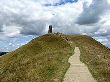
Erosion caused by the feet of the increasing number of visitors was also a problem and paths were laid to enable them to reach the summit without damaging the terraces.
[58] A model vaguely based on Glastonbury Tor (albeit with a tree instead of the tower) was incorporated into the opening ceremony of the 2012 Summer Olympics in London.
[65] The Tor has been associated with the name Avalon, and identified with King Arthur, since the alleged discovery of his and Queen Guinevere's neatly labelled coffins in 1191, recounted by Gerald of Wales.
[66][67] Author Christopher L. Hodapp asserts in his book The Templar Code for Dummies that Glastonbury Tor is one of the possible locations of the Holy Grail, because it is close to the monastery that housed the Nanteos Cup.
[68] The Tor has been a place of Christian pilgrimage at least since the 11th-century and continues to be so, both because of the long-standing dedication to St. Michael the Archangel (the patron of many sacred mountains and hills) and more recently because of the martyrdoms of the three beatified Benedictine monks on its summit in the 16th-century Abbot Whiting, John Thorne and Roger James.
[46][47][48] [57] With the 19th-century resurgence of interest in Celtic mythology, the Tor became associated with Gwyn ap Nudd, the first Lord of the Otherworld (Annwn) and later King of the Fairies.
[74] The theory was first put forward in 1927 by Katherine Maltwood,[75][76] an artist with interest in the occult, who thought the zodiac was constructed approximately 5,000 years ago.
[77] But the vast majority of the land said by Maltwood to be covered by the zodiac was under several feet of water at the proposed time of its construction,[78] and many of the features such as field boundaries and roads are recent.