Street, Somerset
[1] On a dry spot in the Somerset Levels, at the end of the Polden Hills, it is two miles (three kilometres) southwest of Glastonbury.
One Quaker family, the Clarks, started a business in sheepskin rugs, woollen slippers and, later, boots and shoes.
South of Street are the Walton and Ivythorn Hills and East Polden Grasslands biological Sites of Special Scientific Interest.
The Anglican Parish Church of The Holy Trinity dates from the 14th century and has been designated by English Heritage as a Grade I listed building.
The settlement's earliest known name is Lantokay, meaning the sacred enclosure of Kea, a Celtic saint.
The Blue Lias consists of a sequence of limestone and shale layers, laid down in latest Triassic and early Jurassic times, between 195 and 200 million years ago.
Remains of Roman villas exist on the south edge of Street near Marshalls Elm and Ivythorn.
Buried remains of a Roman road were excavated in the early 20th century on the flood-plain of the river Brue between Glastonbury and Street.
The form of the large churchyard suggests a lan, a sacred area of a kind that was built in the first half of the 6th century.
[9] Llan or Lan is a common place name element in Brythonic languages such as Welsh, Cornish, Breton, Cumbric, and possibly Pictish.
[10] One biography of St Gildas has the saint spending some time in Glastonbury Abbey, and moving to a site by the river, where he built a chapel to the Holy Trinity and there died.
[15] Street is in the Glastonbury and Somerton parliamentary constituency, which elects one Member of Parliament (MP) by the first past the post system.
Street is twinned with Isny im Allgäu, a town in south-eastern Baden-Württemberg (Germany),[16] and Notre Dame de Gravenchon in Normandy, France.
At the time of King Arthur, the Brue formed a lake just south of the hilly ground on which Glastonbury stands.
Pomparles Bridge stood at the western end of this lake, guarding Glastonbury from the south, and it was here that Sir Bedivere is thought to have thrown the sword Excalibur into the waters after King Arthur fell at the Battle of Camlann.
[19] Before the 13th century, the direct route to the sea at Highbridge was blocked by gravel banks and peat near Westhay.
Walton and Ivythorn Hills support a complex mosaic of semi-natural habitats which includes unimproved calcareous grassland, dense and scattered scrub and broadleaved woodland.
Structural diversity within the habitats, together with the extensive areas of sheltered wood-edge and scrub-edge margins provide ideal conditions for many species of invertebrate.
Its other main interest lies in its suitability as a habitat for the large blue butterfly (Phengaris arion), which has been successfully reintroduced onto the site.
The vegetation consists of wet and dry heath, species-rich bog and carr woodland, with transitions between all these habitats.
Old peat workings and rhynes have a wetland community which includes bulrush (Typha latifolia), yellow flag iris (pseudacorus), cyperus-like sedge (Carex pseudocyperus) and lesser bur-reed (Sparganium natans).
Insects recorded include 33 species of butterflies, 200 moths and 12 grasshoppers and crickets, with several notable rarities.
[26] In the summer the Azores high pressure affects the south-west of England, however convective cloud sometimes forms inland, reducing the number of hours of sunshine.
In summer, a large proportion of the rainfall is caused by sun heating the ground leading to convection and to showers and thunderstorms.
[26] The Society of Friends established itself here in the mid-17th century, and among the close-knit group of Quaker families were the Clarks: Cyrus Clark started a business in sheepskin rugs, later joined by his brother James, who introduced the production of woollen slippers and then boots and shoes.
[27] Under James's son, William, the business flourished, and most of the profits were ploughed back into employee welfare, housing and education.
The Shoe Museum provides information about the history of Clarks and footwear manufacture in general,[30] and a selection of shop display showcards from the 1930s, the 1950s and the 1960s,[31] and television advertisements.
The company, through the Society of Friends, also had its own small sanatorium and convalescent home on Ivythorn Hill overlooking the village.
[35] A number of bus services serve Street including route 376 to Bristol via Wells which is operated by First West of England and runs every hour.
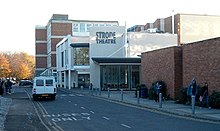
[43] In 1999 the theatre was expanded with a new foyer, bar and box office along with improved rehearsal space and stage access, at a cost of £750,000 by the Steel, Coleman Davis partnership who received an award for the design.