Graham Lakes (Minnesota)
West Graham Lake is an oval shaped body of water that extends east-to-west slightly more than one mile (1.6 km).
Another creek runs from East Graham Lake, and eventually flows into the Des Moines River.
[3][4] When a route for the St. Paul and Sioux City Railway was surveyed in 1871, it was located far south of the Graham Lakes region.
Graham served as a commissioner for the survey of the northeast segment of the boundary between the United States and Canada from 1840 until 1843.
East Graham is managed primarily for walleye and northern pike and secondarily for black crappie and yellow perch.
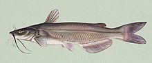
West Graham is primarily managed for walleye with black crappie and channel catfish as secondary species.
A population assessment conducted on June 4, 2007 found that walleye range from 6.9 to 20 inches (510 mm) in length.
[6] Fury Island and Maka-Oicu County Parks are located on East and West Graham Lakes.
Maka-Oicu County Park is located on the northeast shore of West Graham Lake and provides for camping, lake access, natural areas, swimming beach, picnic areas, historic site and general park activities.
Maka-Oicu Park also has a one-room cabin with four padded bunks, a table inside and a small refrigerator.