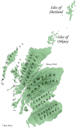
Grampian Mountains
The range includes many of the highest mountains in the British Isles, including Ben Nevis (whose peak contains the highest point in the British Isles at 1,345 m or 4,413 ft above sea level) and Ben Macdui (whose peak contains second-highest at 1,309 m or 4,295 ft).
This view is still held by many today, and they have no single name in the Scottish Gaelic language or the Doric dialect of Lowland Scots.
The Roman historian Tacitus recorded Mons Graupius as the site of the defeat of the native Caledonians by Gnaeus Julius Agricola c. 83 AD.
[4] The name Grampians is believed to have first been applied to the mountain range in 1520 by the Scottish historian Hector Boece, perhaps an adaptation of the incorrect Mons Grampius.
However Robert Gordon, writing in the 1650s, used the term Grampians to refer to hills on either side of the River Dee, and thus explicitly included the Cairngorms within the range.
[citation needed] The Quaternary glaciation (<2.6 Ma) eroded the region significantly, and glacial deposits, such as tills, are largely those of the last Ice Age (< 20 Ka).