Grande Sure
[1] The Brittany-born Antonin Macé, who had become a professor of history at Grenoble University, published a series of articles, particularly in the Bulletin officiel des chemins de fer, mentioning La Grande Sure in 1860.
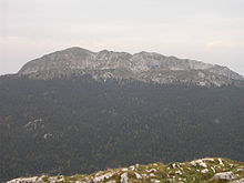
In the Pays Voironnais region, from where it is particularly visible, La Grande Sure is shaped like a molar, leaning slightly to the east due to the inflection at the ends of its summit crest.
[1] La Grande Sure is composed of Fontanil limestone corresponding to the Valanginian stage, formed by marine sedimentation in the Alpine Tethys during the Early Cretaceous.
[8][10] In the opposite direction from the summit, the western side of La Grande Sure is composed of Berriasian limestone and limestone-marl alternations.
[8] La Grande Sure is formed by the western side of the vast Proveysieux syncline, centered on the Charmette mountain pass.
[8] The rocky promontories to the west of the summit, at the level of Pierre Taillée and Les Trois Fontaines, form an anticline that straddles the Voreppe syncline.
Late tectonic folding of the Voreppe overlap, followed by differential erosion in the Quaternary period, completed the exposure of the older rocks.
As a result, the snowpack depth at the Porte mountain pass (1,326 m) is around one meter at the end of February but has reached record levels of 200 to 230 centimeters during the same period in 1979, 1982, and 1985.
[14][15] The Corsican Mouflon was introduced in 1970 and has a population of around 100 individuals, moving from Charmant Som in summer to the outskirts of La Grande Sure in winter.
Other species include Montpellier Fringed Pink, the St John's Wort (also called Vulnéraire du Dauphiné), the Pink Cinquefoil, the Daphne alpina, the Epipactis leptochila Orchid, the Perennial Honesty, the Sermontain broomrape (Orobanche laserpitii-sileris) and a species of fern called the Hard Shield-fern.
After the Chalet de la Charmette, 200 mts north of the pass, the forest road gradually turns into a simple pathway heading northwest.
Following a short descent to the Sure mountain pass, the pathway climbs up along the eastern side of La Grande Sure until it reaches the summit, to the southwest, after an additional thirty minutes’ walk.
[1][21] The ascent can also be made from the west, from Les Trois Fontaines, on the eastern side of the Placette mountain pass, with an altitude of 1,350 meters.
After a series of zigzags leading northwards, the pathway curves eastwards, passing a natural belvedere after around 45 minutes, and then the Pas de la Miséricorde, featuring a relatively long passageway, equipped with cables, which is exposed to both drops and rockfalls.
Shortly afterwards, it is possible to head south through a natural cirque on the Charminelle pathway, which is marked in yellow for hikers according to the Charte Officielle du Balisage et de la Signalisation.
[23][24] From the Pas de la Miséricorde, it is also possible to continue eastwards with a steady climb along the Hérétang stream up to Velouse, then either back up to the Sure[1] mountain pass or up the southern ridge.
The final section is a passageway, which is signposted by a stele in the shape of a small metal cross and orange-yellow markers for hikers.
[26] A new climbing route called Une sauterelle à la Sure, with a height of 130 meters, has been opened in the pillar to the south of the summit.