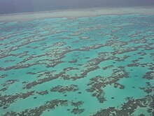
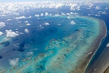
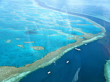
Great Barrier Reef
Other environmental pressures on the reef and its ecosystem include runoff of humanmade pollutants, climate change accompanied by mass coral bleaching, dumping of dredging sludge and cyclic population outbreaks of the crown-of-thorns starfish.
[13][14] The Great Barrier Reef has long been known to and used by the Aboriginal Australian and Torres Strait Islander peoples, and is an important part of local groups' cultures and spirituality.
[16] A March 2016 report stated that coral bleaching was more widespread than previously thought, seriously affecting the northern parts of the reef as a result of warming ocean temperatures.
[19] In March 2017, the journal Nature published a paper showing that huge sections of an 800-kilometre (500 mi) stretch in the northern part of the reef had died in the course of 2016 of high water temperatures, an event that the authors put down to the effects of global climate change.
[20] The percentage of baby corals being born on the Great Barrier Reef dropped drastically in 2018 and scientists are describing it as the early stage of a "huge natural selection event unfolding".
[22] In March 2022, another mass bleaching event has been confirmed, which raised further concerns about the future of this reef system, especially when considering the possible effects of El Niño weather phenomenon.
[23] The Australian Institute of Marine Science conducts annual surveys of the Great Barrier Reef's status, and the 2022 report showed the greatest recovery in 36 years.
[24] The Great Barrier Reef has long been known to and used by the Aboriginal Australian and Torres Strait Islander peoples, and is an important part of local groups' cultures and spirituality.
On 11 June 1770 Cook's ship, HMS Endeavour, ran aground on a shoal south of the present-day location of Cooktown, requiring seven weeks to repair.
By around 13,000 years ago the sea level was only 60 metres (200 ft) lower than the present day, and corals began to surround the hills of the coastal plain, which were, by then, continental islands.
More than 20 ships were recorded lost in the region between 1791 and 1850, Surveys between 1815 and 1860 by Phillip Parker King in the Mermaid, Francis Price Blackwood in HMS Fly, Owen Stanley in the Rattlesnake, and Henry Mangles Denham in the Herald led to considerable navigational improvements, as they outlined the contrasting advantages and perils of the Inner Route (between Australia's east coast and the western edge of the reefs) and the Outer Route, in the open sea.
[48] Seventeen species of sea snake live on the Great Barrier Reef in warm waters up to 50 metres (160 ft) deep and are more common in the southern than in the northern section.
[61] According to a 2012 study by the National Academy of Sciences, since 1985, the Great Barrier Reef has lost more than half of its corals with two-thirds of the loss occurring from 1998 due to the factors listed before.
[71] Climate change has implications for other forms of reef life – some fish's preferred temperature range leads them to seek new habitat, thus increasing chick mortality in predatory seabirds.
[78] Sediments containing high levels of copper and other heavy metals sourced from the Ok Tedi Mine in Papua New Guinea are a potential pollution risk for the far northern Great Barrier Reef and Torres Strait regions.
[84] Farming fertiliser runoff release nitrogen, phosphorus, and potassium into the oceanic ecosystem, and these limiting nutrients cause massive algal growth which eventually leads to a reduction in oxygen available for other creatures in a process called eutrophication.
A study by Katharina Fabricius and Glen Death of Australian Institute of Marine Science found that hard corals numbers were almost double on reefs that were far from agricultural areas.
Fishing also impacts the reef through increased water pollution from boats, by-catch of unwanted species (such as dolphins and turtles) and habitat destruction from trawling, anchors and nets.
[88] As of the middle of 2004, approximately one-third of the Great Barrier Reef Marine Park is protected from species removal of any kind, including fishing, without written permission.
[92] On 3 April 2010, the bulk coal carrier Shen Neng 1 ran aground on Douglas Shoals,[93] spilling up to four tonnes of oil into the water and causing extensive damage to the reef.
[110] The Australian and Queensland governments have contributed about $142.5 million to their National Environmental Science Program which is how they've collected much of their data regarding threats to the Great Barrier Reef.
[110] In addition, the Reef 2050 Water Quality Improvement Plan was announced in 2018 in order to help transition local communities, agricultural organizations and industries to more sustainable practices.
[115] On 11 June 1770, HM Bark Endeavour, captained by explorer James Cook, ran aground on the Great Barrier Reef, sustaining considerable damage.
Some key achievements made since the plan's initial passing in 2003 were the establishment of the Reef Quality Partnership to set targets, report findings and monitor progress towards targets, improved land condition by landowners was rewarded with extended leases, Water Quality Improvement Plans were created to identify regional targets and identified management changes that needed to be made to reach those targets, Nutrient Management Zones have been created to combat sediment loss in particular areas, education programs have been started to help gather support for sustainable agriculture, changes to land management practices have taken place through the implementation of the Farm Management Systems and codes of practice, the creation of the Queensland Wetland program and other achievements were made to help improve the water quality flowing into the coral reefs.
According to corresponding approval documents, the process will create around 3 million cubic metres of dredged seabed that will be dumped within the Great Barrier Reef marine park area.
[130] On 31 January 2014, the GBRMPA issued a dumping permit that will allow three million cubic metres of sea bed from Abbot Point, north of Bowen, to be transported and unloaded in the waters of the Great Barrier Reef Marine Park.
Potential significant harms have been identified in relation to dredge spoil and the process of churning up the sea floor in the area and exposing it to air: firstly, new research shows the finer particles of dredge spoil can cloud the water and block sunlight, thereby starving sea grass and coral up to distances of 80 km away from the point of origin due to the actions of wind and currents.
[131]The approval was provided with a corresponding set of 47 new environmental conditions that include the following: The Australian Federal Government announced on 13 November that there would now be a ban on the dumping of dredge spoil in the Great Barrier Reef Marine Park.
[133] Due to its vast biodiversity, warm clear waters and accessibility from the tourist boats called "live aboards", the reef is a very popular destination, especially for scuba divers.
Four traditional owners groups agreed to cease the hunting of dugongs in the area in 2011 due to their declining numbers, partially accelerated by seagrass damage from Cyclone Yasi.